Red River, New Mexico
| Red River, New Mexico | |
|---|---|
| Town | |
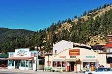
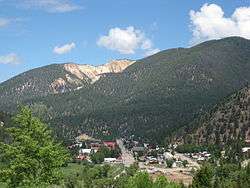 The town of Red River, New Mexico | |
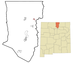 Location of Red River, New Mexico | |
 Red River, New Mexico Location in the United States | |
| Coordinates: 36°42′23″N 105°24′19″W / 36.70639°N 105.40528°WCoordinates: 36°42′23″N 105°24′19″W / 36.70639°N 105.40528°W | |
| Country | United States |
| State | New Mexico |
| County | Taos |
| Date Established | 1895 |
| Government | |
| • Mayor | Linda Calhoun |
| Area | |
| • Total | 1.0 sq mi (2.7 km2) |
| • Land | 1.0 sq mi (2.6 km2) |
| • Water | 0.0 sq mi (0.0 km2) |
| Elevation | 8,671 ft (2,643 m) |
| Population (2010) | |
| • Total | 477 |
| • Estimate (2016)[1] | 477 |
| • Density | 480/sq mi (180/km2) |
| Time zone | UTC-7 (Mountain (MST)) |
| • Summer (DST) | UTC-6 (MDT) |
| ZIP code | 87558 |
| Area code(s) | 575 |
| FIPS code | 35-62200 |
| GNIS feature ID | 0910074 |
| Website | www.redriver.org |
Red River is a resort town in Taos County, New Mexico, United States, located in the Sangre de Cristo Mountains. The population was 477 at the 2010 census. Red River is a prime spot for tourism on the Enchanted Circle Scenic Byway, and is 36 miles (57.9 kilometres) from Taos, New Mexico.
History
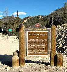
The town of Red River began in late in the 19th century, when miners from nearby Elizabethtown in the Moreno Valley were drawn in by gold strikes in the area and trappers sought game. It was named after the perennial stream, Red River, that flowed through the town, coming from the northern slopes of Wheeler Peak. By 1895, Red River was a booming mining camp, with gold, silver and copper in some abundance, and a population estimated at three thousand. Mining hit its peak in 1897, and by 1905 the mining and the population dwindled but the town survived, gaining a reputation as a great getaway from hot weather and as a trout fishing paradise. The last serious mining efforts extended until 1931. By that time tourism had become the principal economic childhood.[2]
Geography
Red River is located at 36°42′23″N 105°24′19″W / 36.70639°N 105.40528°W (36.706311, -105.405271).[3] Red River is located in the southern Rocky MountainsSangre de Cristo Mountains and is surrounded by the Carson National Forest.
According to the United States Census Bureau, the town has a total area of 1.0 square mile (2.6 km2), all land.
Red River passes through the Enchanted Circle Scenic Byway, also known as New Mexico Route 38.
Census Data
| Historical population | |||
|---|---|---|---|
| Census | Pop. | %± | |
| 1980 | 332 | — | |
| 1990 | 387 | 16.6% | |
| 2000 | 484 | 25.1% | |
| 2010 | 477 | −1.4% | |
| Est. 2016 | 477 | [1] | 0.0% |
| U.S. Decennial Census[4] | |||
As of the census[5] of 2000, there were 484 people, 234 households, and 138 families residing in the town. The population density was 474.9 inhabitants per square mile (183.2/km²). There were 880 housing units at an average density of 863.5 per square mile (333.1/km²). The racial makeup of the town was 92.56% White, 1.03% Native American, 3.72% from other races, and 2.69% from two or more races. Hispanic or Latino of any race were 9.30% of the population.
There were 0 households out of which 20.1% had children under the age of 18 living with them, 49.6% were married couples living together, 5.6% had a female householder with no husband present, and 40.6% were non-families. 32.9% of all households were made up of individuals and 6.8% had someone living alone who was 65 years of age or older. The average household size was 2.07 and the average family size was 2.60.
In the town, the population was spread out with 16.7% under the age of 18, 7.0% from 18 to 24, 27.1% from 25 to 44, 35.5% from 45 to 64, and 13.6% who were 65 years of age or older. The median age was 45 years. For every 100 females, there were 97.6 males. For every 100 females age 18 and over, there were 98.5 males.
The median income for a household in the town was $31,667, and the median income for a family was $39,792. Males had a median income of $31,667 versus $19,750 for females. The per capita income for the town was $17,883. About 5.4% of families and 9.7% of the population were below the poverty line, including 7.4% of those under age 18 and none of those age 65 or over.
Climate
| Climate data for Red River, NM | |||||||||||||
|---|---|---|---|---|---|---|---|---|---|---|---|---|---|
| Month | Jan | Feb | Mar | Apr | May | Jun | Jul | Aug | Sep | Oct | Nov | Dec | Year |
| Average high °F (°C) | 36.5 (2.5) |
39.0 (3.9) |
44.6 (7) |
53.7 (12.1) |
62.9 (17.2) |
73.1 (22.8) |
76.3 (24.6) |
74.2 (23.4) |
69.0 (20.6) |
58.5 (14.7) |
45.6 (7.6) |
38.0 (3.3) |
56 (13.3) |
| Average low °F (°C) | 4.6 (−15.2) |
8.1 (−13.3) |
15.2 (−9.3) |
22.9 (−5.1) |
29.4 (−1.4) |
35.7 (2.1) |
41.2 (5.1) |
40.6 (4.8) |
34.2 (1.2) |
25.6 (−3.6) |
14.7 (−9.6) |
6.4 (−14.2) |
23.2 (−4.9) |
| Average precipitation inches (mm) | 1.12 (28.4) |
1.26 (32) |
1.81 (46) |
1.82 (46.2) |
1.72 (43.7) |
1.37 (34.8) |
3.07 (78) |
3.08 (78.2) |
1.76 (44.7) |
1.55 (39.4) |
1.22 (31) |
1.17 (29.7) |
20.96 (532.4) |
| Average snowfall inches (cm) | 20.3 (51.6) |
22.2 (56.4) |
29.5 (74.9) |
21.9 (55.6) |
7.6 (19.3) |
0.1 (0.3) |
0.4 (1) |
0 (0) |
0.7 (1.8) |
7.9 (20.1) |
16.6 (42.2) |
19.2 (48.8) |
146.5 (372.1) |
| Source: The Western Regional Climate Center [6] | |||||||||||||
Economy
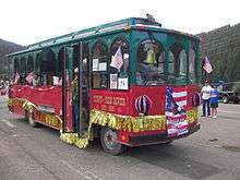
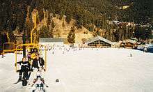
The main industry in Red River is tourism. Red River is located at the base of the Red River Ski Area, located 8,750 feet above sea level in the southern Rocky Mountains. Winter activities include skiing, snowboarding and snowmobiling. In summertime, visitors can hike, bike, fish, and ride horseback in the mountains. The town is serviced by a trolley and bus system which provides access into the upper valley.
References
- 1 2 "Population and Housing Unit Estimates". Retrieved June 9, 2017.
- ↑ Pearson, Jim Berry (1986) The Red River-Twining area: a New Mexico mining story University of New Mexico Press, Albuquerque, ISBN 0-8263-0875-9
- ↑ "US Gazetteer files: 2010, 2000, and 1990". United States Census Bureau. 2011-02-12. Retrieved 2011-04-23.
- ↑ "Census of Population and Housing". Census.gov. Retrieved June 4, 2015.
- ↑ "American FactFinder". United States Census Bureau. Retrieved 2008-01-31.
- ↑ "Climate Statistics for Lead, SD". Retrieved January 29, 2012.
External links
| Wikivoyage has a travel guide for Red River. |
![]()
Municipalities and communities of Taos County, New Mexico, United States | ||
|---|---|---|
| Towns | 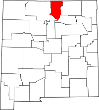 | |
| Villages | ||
| CDPs | ||
| Other unincorporated communities | ||
| Indian reservation | ||