Costilla, New Mexico
| Costilla, New Mexico | |
|---|---|
| Census-designated place | |
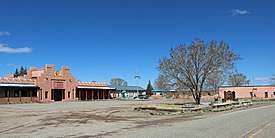 La Plaza de Arriba in Costilla. | |
 Costilla, New Mexico | |
| Coordinates: 36°58′33″N 105°31′52″W / 36.97583°N 105.53111°WCoordinates: 36°58′33″N 105°31′52″W / 36.97583°N 105.53111°W | |
| Country | United States |
| State | New Mexico |
| County | Taos |
| Area[1] | |
| • Total | 3.056 sq mi (7.92 km2) |
| • Land | 3.056 sq mi (7.92 km2) |
| • Water | 0 sq mi (0 km2) |
| Elevation | 7,812 ft (2,381 m) |
| Population (2010)[2] | |
| • Total | 205 |
| • Density | 67/sq mi (26/km2) |
| Time zone | UTC-7 (Mountain (MST)) |
| • Summer (DST) | UTC-6 (MDT) |
| ZIP code | 87524 |
| Area code(s) | 575 |
| GNIS feature ID | 898749[3] |
Costilla is a census-designated place in Taos County, New Mexico, United States. Its population was 205 as of the 2010 census.[2] Costilla has a post office with ZIP code 87524.[4][5] New Mexico State Road 196 and New Mexico State Road 522 intersect in the community.
Geography
Costilla is located at 36°58′43″N 105°32′07″W / 36.978643°N 105.535269°W. According to the U.S. Census Bureau, the community has an area of 3.056 square miles (7.92 km2), all of it land.[1]
References
- 1 2 "2010 Census Gazetteer Files: Places: New Mexico". U.S. Census Bureau. Archived from the original on July 14, 2014. Retrieved July 11, 2014.
- 1 2 "American FactFinder". United States Census Bureau. Archived from the original on 2013-09-11. Retrieved 2011-05-14.
- ↑ "Costilla". Geographic Names Information System. United States Geological Survey.
- ↑ "Postmaster Finder - Post Offices by ZIP Code". United States Postal Service. Retrieved July 11, 2014.
- ↑ United States Postal Service (2012). "USPS - Look Up a ZIP Code". Retrieved 2012-02-15.
Municipalities and communities of Taos County, New Mexico, United States | ||
|---|---|---|
| Towns | 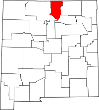 | |
| Villages | ||
| CDPs | ||
| Other unincorporated communities | ||
| Indian reservation | ||
This article is issued from
Wikipedia.
The text is licensed under Creative Commons - Attribution - Sharealike.
Additional terms may apply for the media files.