Llano, New Mexico
| Llano | |
|---|---|
| Unincorporated community | |
 Llano Location within the state of New Mexico  Llano Llano (the US) | |
| Coordinates: 36°08′24″N 105°40′54″W / 36.14000°N 105.68167°WCoordinates: 36°08′24″N 105°40′54″W / 36.14000°N 105.68167°W | |
| Country | United States |
| State | New Mexico |
| County | Taos |
| Elevation | 8,054 ft (2,455 m) |
| Time zone | UTC-7 (Mountain (MST)) |
| • Summer (DST) | UTC-6 (MDT) |
| ZIP codes | 87543[1] |
| Area code(s) | 575 |
| GNIS feature ID | 908081[2] |
Llano is an unincorporated community located in Taos County, New Mexico, United States. The community is located on New Mexico State Road 73 2.1 miles (3.4 km) south of Peñasco.
References
- ↑ United States Postal Service. "USPS - Look Up a ZIP Code". Retrieved November 29, 2014.
- ↑ "Llano". Geographic Names Information System. United States Geological Survey.
Municipalities and communities of Taos County, New Mexico, United States | ||
|---|---|---|
| Towns | 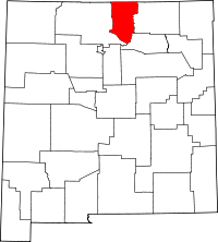 | |
| Villages | ||
| CDPs | ||
| Other unincorporated communities | ||
| Indian reservation | ||
This article is issued from
Wikipedia.
The text is licensed under Creative Commons - Attribution - Sharealike.
Additional terms may apply for the media files.