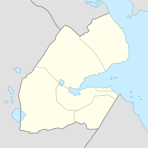
Randa, Djibouti
| Randa راندا | |
|---|---|
| Town | |
 | |
 Randa راندا Location in Djibouti | |
| Coordinates: 11°50′49″N 42°39′38″E / 11.84694°N 42.66056°ECoordinates: 11°50′49″N 42°39′38″E / 11.84694°N 42.66056°E | |
| Country |
|
| Region | Tadjoura |
| District | Randa |
| Area | |
| • Total | 0.44 km2 (0.17 sq mi) |
| Elevation | 927 m (3,041 ft) |
| Population | |
| • Total | 1,023 |
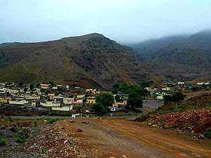
Randa (Arabic: راندا) is a town in central Djibouti in the largest region, that of Tadjoura, it is the capital of the Randa District. The settlement lies in a small valley, north of the Day Forest National Park in the Goda Mountains. It lies at the junction of two solely domestic roads, the N11 and N12. It is within 10 miles (16 km) of the national park.
History
Randa has played an important role in trade between the port of Tadjoura, and the hinterland, once dynamic and prosperous possessing a well on its bed of wadi which crossed it and has one of the mildest climates in Djibouti. The beginning of the civil conflict in December 1991, when the FRUD rebels captured Randa and neighbouring towns. However, the Djiboutian Army re-took the town in October 1993.
Overview
The settlement lies in a small valley, north of the RN9 road which leaves the coast to the south to head west towards Dorra. It is within 10 miles (16 km) of the Day Forest National Park in the Goda Mountains to the south.
| Name | Distance |
|---|---|
| Bankouale | 1.8 miles (2.9 km) |
| Airolaf | 5.3 miles (8.5 km) |
| Tadjoura | 15.8 miles (25.4 km) |
| Dorra | 24.3 miles (39.1 km) |
| `Assa Gaila | 23.8 miles (38.3 km) |
| Medeho | 26.2 miles (42.2 km) |
| Balho | 34.6 miles (55.7 km) |
Geography
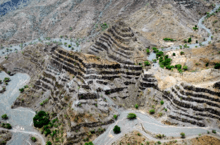
Randa's altitude gives the settlement and the surrounding area a milder climate than the Djibouti City coastal area, where the weather is typically hotter. A river runs through the town. Often dry, the watercourse divides Randa in half. The surrounding mountains to the west are high and jagged, lengthening journeys in that direction.
Wildlife
Due to the fertility of the region, experienced in many years, wild mammals such as gazelle and mountain goats migrate to the area either to breed or to live and graze on the grassland savannah.
Climate
The town seldom experiences either hot or cold weather, due to the high altitude. The settlement has relatively high average precipitation for the region, twice that of Tadjourah city for example. Average monthly temperatures in Randa range from 14°C in the months of December and January to 34.7°C in June.
Randa has a hot semi-arid climate (BSh) in Köppen-Geiger system.
| Climate data for Randa | |||||||||||||
|---|---|---|---|---|---|---|---|---|---|---|---|---|---|
| Month | Jan | Feb | Mar | Apr | May | Jun | Jul | Aug | Sep | Oct | Nov | Dec | Year |
| Average high °C (°F) | 23.6 (74.5) |
23.9 (75) |
25.9 (78.6) |
28.0 (82.4) |
31.2 (88.2) |
34.4 (93.9) |
34.7 (94.5) |
33.7 (92.7) |
32.1 (89.8) |
28.6 (83.5) |
25.8 (78.4) |
24.0 (75.2) |
28.8 (83.9) |
| Daily mean °C (°F) | 18.6 (65.5) |
19.3 (66.7) |
20.9 (69.6) |
23.1 (73.6) |
25.8 (78.4) |
28.9 (84) |
28.9 (84) |
28.1 (82.6) |
27.2 (81) |
23.4 (74.1) |
20.8 (69.4) |
19.2 (66.6) |
23.7 (74.6) |
| Average low °C (°F) | 13.7 (56.7) |
14.8 (58.6) |
16.0 (60.8) |
18.2 (64.8) |
20.5 (68.9) |
23.5 (74.3) |
23.1 (73.6) |
22.5 (72.5) |
22.3 (72.1) |
18.2 (64.8) |
15.8 (60.4) |
14.4 (57.9) |
18.6 (65.5) |
| Average precipitation mm (inches) | 39 (1.54) |
36 (1.42) |
20 (0.79) |
27 (1.06) |
12 (0.47) |
7 (0.28) |
25 (0.98) |
38 (1.5) |
40 (1.57) |
13 (0.51) |
37 (1.46) |
31 (1.22) |
325 (12.8) |
| Source: Climate-Data.org, altitude: 1034m[1] | |||||||||||||
References
- ↑ "Climate: Randa - Climate graph, Temperature graph, Climate table". Climate-Data.org. Retrieved 25 September 2013.