Rainy River, Ontario
| Rainy River | |
|---|---|
| Town (single-tier) | |
| Town of Rainy River | |
 | |
 Rainy River | |
| Coordinates: 48°43′N 94°34′W / 48.717°N 94.567°WCoordinates: 48°43′N 94°34′W / 48.717°N 94.567°W | |
| Country |
|
| Province |
|
| District | Rainy River |
| Settled | 1895 |
| Incorporated | 1901 (township) |
| Incorporated | 1902 (town) |
| Government | |
| • Type | Town |
| • Mayor | Deborah Ewald |
| • Federal riding | Thunder Bay—Rainy River |
| • Prov. riding | Kenora—Rainy River |
| Area[1] | |
| • Land | 2.99 km2 (1.15 sq mi) |
| Population (2011)[1] | |
| • Total | 842 |
| • Density | 281.5/km2 (729/sq mi) |
| Time zone | UTC—6 (CST) |
| • Summer (DST) | UTC—5 (CDT) |
| Postal code | P0W 1L0 |
| Area code(s) | 807 |
| Website | www.rainyriver.ca |
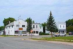
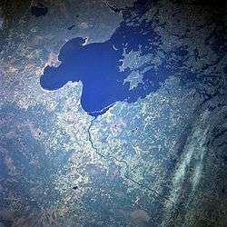
Rainy River is a town in north-western Ontario, Canada, southeast of Lake of the Woods. Rainy River is situated on the eponymous Rainy River, which forms part of the Ontario-Minnesota segment of the Canada–US border. Opposite Rainy River across the river is the town of Baudette, Minnesota. The two towns are connected by the Baudette – Rainy River International Bridge. Rainy River is at the northwestern terminus of Ontario Highway 11.
Rainy River is famous for being frequently (though wrongly) seen as being at being the opposite end of Toronto's Yonge Street, which has led to the street being dubbed the "longest street in the world", due to a false conflation between the street and Highway 11, which the street was once the southernmost section of. The street name for the highway through the town is actually Atwood Avenue.
History
Incorporated as the town of Rainy River in 1904, the actual community was first formed around 1895 along the East shore of the Rainy River about 2 km from the current town center by a group of lumbermen whose mill was purchased by the Beaver Mills Lumber Company in 1898. The small village took the name Beaver Mills until it was incorporated as a town. In 1901 the Ontario and Rainy River Railway completed a bridge connecting Minnesota to Ontario, but Beaver Mills town site was in the way of the Eastern end and so they created a new town further up river and in between the two large Mills. The only method of transport at the time was by Steam ship so parts of the bridge arrived addressed to "Rainy River". The town eventually accepted this as their name.[2]
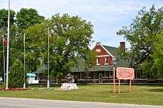
The town grew rapidly because of the thriving lumber industry and its two large Mills and bolstered by the Railway. In 1910, a forest fire known as The Great Fire of 1910 originating in northern Minnesota swept north and destroyed the Mills. Across the South side of the River the two villages of Baudette and Spooner were completely burned out with much of the population being saved at the very last moment by a group of brave citizens from Rainy River who backed a Train of box cars across the bridge and pulled them out. The mill industry relocated as a result, contributing to a drop in population from more than 2000 people to its current less than 800.
However, due to the railroad, (absorbed by the Canadian Northern Railway in 1915) since taken over by Canadian National Railways, the growing hunting/fishing tourism industry, the town remained firmly established. The town has had many industries in the past, a Rail Round House, in the 1960s the Rainy River Boat company, in the 1970s Arctic Cat Apparel among some of the major ones, all have now closed and the current town faces a dismal future.[3]
Demographics
| Canada census – Rainy River, Ontario community profile | |||
|---|---|---|---|
| 2011 | 2006 | ||
| Population: | 842 (−7.4% from 2006) | 909 (−7.3% from 2001) | |
| Land area: | 2.99 km2 (1.15 sq mi) | 2.99 km2 (1.15 sq mi) | |
| Population density: | 281.5/km2 (729/sq mi) | 303.9/km2 (787/sq mi) | |
| Median age: | 50.8 (M: 49.2, F: 51.9) | 47.8 (M: 44.8, F: 49.3) | |
| Total private dwellings: | 457 | 452 | |
| Median household income: | $49,117 | ||
| References: 2011[4] 2006[5] earlier[6] | |||
Population trend:[7]
- Population in 2011: 842
- Population in 2006: 909
- Population in 2001: 981
- Population in 1996: 1008
- Population in 1991: 968
Government
Federal representation
The town is in the Canadian electoral district of Thunder Bay—Rainy River, which elects one Member of Parliament (MP) in Canada Parliament to represented all of the district. Currently, the MP is Don Rusnak.
City Mayor and Council
The city is headed by Rainy River Mayor and six elected city councillors.[8]
Notable people
- Bronko Nagurski, Hall of fame NFL player
- James Arthur Mathieu, businessman and politician
- Angela Bulloch, sound and installation artist
See also
References
- 1 2 "Rainy River census profile". 2011 Census of Population. Statistics Canada. Retrieved 2012-03-29.
- ↑ "History « Town of Rainy River". Retrieved 2012-08-19.
- ↑ "Economic Development « Town of Rainy River". Retrieved 2012-08-19.
- ↑ "2011 Community Profiles". Canada 2011 Census. Statistics Canada. July 5, 2013. Retrieved 2012-03-29.
- ↑ "2006 Community Profiles". Canada 2006 Census. Statistics Canada. March 30, 2011. Retrieved 2011-05-05.
- ↑ "2001 Community Profiles". Canada 2001 Census. Statistics Canada. February 17, 2012.
- ↑ Statistics Canada: 1996, 2001, 2006 census
- ↑ http://www.rainyriver.ca/mayor-and-council.html
External links
| Wikisource has the text of The New Student's Reference Work article Rainy River. |
- Town of Rainy River
- The Rainy River Record
- Canada Census 1901
- Deputy of Thunder Bay - Rainy River / Don Rusnak
Places adjacent to Rainy River, Ontario | |
|---|---|
| Towns | 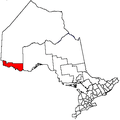 | |
|---|---|---|
| Townships | ||
| First Nations | ||
| Indian reserves |
| |
| Unorganized areas | ||
| Unincorporated communities | ||
| ||