Dawson, Ontario
| Dawson | |
|---|---|
| Township (single-tier) | |
| Township of Dawson | |
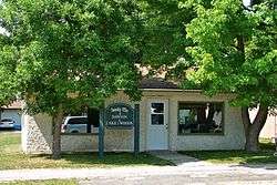 Township office of Dawson in Rainy River | |
 Dawson | |
| Coordinates: 48°45′N 94°29′W / 48.750°N 94.483°WCoordinates: 48°45′N 94°29′W / 48.750°N 94.483°W | |
| Country |
|
| Province |
|
| District | Rainy River |
| Formed | 1 January 1997 |
| Government | |
| • Mayor | Bill Langner |
| • Federal riding | Thunder Bay—Rainy River |
| • Prov. riding | Kenora—Rainy River |
| Area[1] | |
| • Land | 338.35 km2 (130.64 sq mi) |
| Elevation[2] | 335 m (1,099 ft) |
| Population (2011)[1] | |
| • Total | 563 |
| • Density | 1.7/km2 (4/sq mi) |
| Time zone | UTC-6 (CST) |
| • Summer (DST) | UTC-5 (CDT) |
| Postal Code FSA | P0W 1L0 |
| Area code(s) | 807 |
Dawson is a township located in Rainy River District in Northwestern Ontario, Canada. The township is located at the mouth of the Rainy River where it flows into Lake of the Woods.
The township was formed on 1 January 1997, when the former incorporated townships of Atwood, Blue, Dilke, and Worthington were amalgamated.
Communities
The primary communities in the township are Blue, McGinnis Creek, Pinewood and Sleeman.
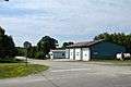 Pinewood
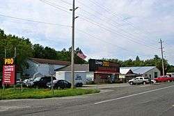
Demographics
| Canada census – Dawson community profile | |||
|---|---|---|---|
| 2011 | 2006 | ||
| Population: | 563 (-9.2% from 2006) | 620 (1.1% from 2001) | |
| Land area: | 338.35 km2 (130.64 sq mi) | 338.35 km2 (130.64 sq mi) | |
| Population density: | 1.7/km2 (4.4/sq mi) | 1.8/km2 (4.7/sq mi) | |
| Median age: | 47.8 (M: 49.1, F: 46.2) | 44.2 (M: 43.3, F: 44.8) | |
| Total private dwellings: | 307 | 323 | |
| Median household income: | $47,175 | ||
| References: 2011[1] 2006[3] earlier[4] | |||
Population trend:[5]
- Population in 2011: 563
- Population in 2006: 620
- Population in 2001: 613
- Population in 1996: 631
- Atwood (township): 273
- Blue (township): 100
- Dilke (township): 153
- Worthington (township): 105
- Population in 1991:
- Atwood (township): 294
- Blue (township): 95
- Dilke (township): 163
- Worthington (township): 110
Climate
| Climate data for Sleeman | |||||||||||||
|---|---|---|---|---|---|---|---|---|---|---|---|---|---|
| Month | Jan | Feb | Mar | Apr | May | Jun | Jul | Aug | Sep | Oct | Nov | Dec | Year |
| Record high °C (°F) | 7 (45) |
11 (52) |
16.5 (61.7) |
31.5 (88.7) |
32.5 (90.5) |
33.5 (92.3) |
35 (95) |
34.5 (94.1) |
34.4 (93.9) |
26.7 (80.1) |
22.2 (72) |
9 (48) |
35 (95) |
| Average high °C (°F) | −11.4 (11.5) |
−7 (19) |
0.3 (32.5) |
10.5 (50.9) |
18.8 (65.8) |
22.3 (72.1) |
25 (77) |
23.4 (74.1) |
17.3 (63.1) |
10.5 (50.9) |
−0.2 (31.6) |
−8.9 (16) |
8.4 (47.1) |
| Daily mean °C (°F) | −17.2 (1) |
−13.2 (8.2) |
−5.6 (21.9) |
4.1 (39.4) |
11.8 (53.2) |
16.2 (61.2) |
19 (66) |
17.4 (63.3) |
11.8 (53.2) |
5.7 (42.3) |
−4.1 (24.6) |
−14 (7) |
2.7 (36.9) |
| Average low °C (°F) | −22.9 (−9.2) |
−19.3 (−2.7) |
−11.4 (11.5) |
−2.2 (28) |
4.8 (40.6) |
9.9 (49.8) |
12.9 (55.2) |
11.4 (52.5) |
6.3 (43.3) |
0.8 (33.4) |
−8 (18) |
−19.1 (−2.4) |
−3.1 (26.4) |
| Record low °C (°F) | −44 (−47) |
−41 (−42) |
−37.5 (−35.5) |
−27.8 (−18) |
−8 (18) |
−2 (28) |
1.1 (34) |
−1.7 (28.9) |
−6 (21) |
−17 (1) |
−39 (−38) |
−43 (−45) |
−44 (−47) |
| Average precipitation mm (inches) | 27.9 (1.098) |
21.6 (0.85) |
30.1 (1.185) |
37.9 (1.492) |
60.4 (2.378) |
107.5 (4.232) |
86.4 (3.402) |
90.5 (3.563) |
69.3 (2.728) |
57.7 (2.272) |
37.2 (1.465) |
23.5 (0.925) |
650 (25.59) |
| Source: Environment Canada[2] | |||||||||||||
See also
References
- 1 2 3 "2011 Community Profiles". Canada 2011 Census. Statistics Canada. July 5, 2013. Retrieved 2012-03-30.
- 1 2 Environment Canada - Canadian Climate Normals 1971–2000, accessed 2011-05-05
- ↑ "2006 Community Profiles". Canada 2006 Census. Statistics Canada. March 30, 2011. Retrieved 2011-05-05.
- ↑ "2001 Community Profiles". Canada 2001 Census. Statistics Canada. February 17, 2012.
- ↑ Statistics Canada: 1996, 2001, 2006 census
Places adjacent to Dawson, Ontario | |
|---|---|
| Towns | 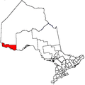 | |
|---|---|---|
| Townships | ||
| First Nations | ||
| Indian reserves |
| |
| Unorganized areas | ||
| Unincorporated communities | ||
| ||
This article is issued from
Wikipedia.
The text is licensed under Creative Commons - Attribution - Sharealike.
Additional terms may apply for the media files.