Region of Queens Municipality
| Region of Queens Municipality | ||
|---|---|---|
| Regional Municipality | ||
| ||
| Motto(s): Rivers, Forest, Sea | ||
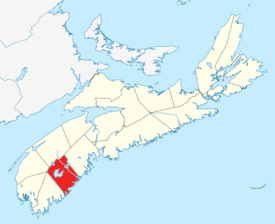 Location of Region of Queens Municipality, Nova Scotia | ||
| Coordinates: 44°02′N 64°43′W / 44.033°N 64.717°WCoordinates: 44°02′N 64°43′W / 44.033°N 64.717°W | ||
| Country |
| |
| Province |
| |
| Incorporated | April 1, 1996 | |
| Electoral Districts Federal |
South Shore—St. Margaret's | |
| Provincial | Queens-Shelburne | |
| Government | ||
| • Type | Queens Regional Council | |
| • Mayor | David Dagley | |
| Area (2016)[1] | ||
| • Land | 2,392.63 km2 (923.80 sq mi) | |
| Population (2016)[1] | ||
| • Total | 10,307 | |
| • Density | 4.3/km2 (11/sq mi) | |
| • Change 2011-2016 |
| |
| • Census ranking | 400 of 5,162 | |
| Time zone | UTC-4 (AST) | |
| • Summer (DST) | UTC-3 (ADT) | |
| Area code(s) | 902, 782 | |
| Dwellings | 6,150 | |
| Median Income* | $36,461 CDN | |
| Website | regionofqueens.com | |
| ||
The Region of Queens Municipality is a Canadian regional municipality located in southwestern Nova Scotia. Queens is the southern gateway of the UNESCO Southwest Nova Biosphere Reserve, where outdoor activities are always close at hand. Campgrounds at Kejimukujik National Park and National Historic Site, Thomas H. Raddall Provincial Park, and several other locations are great places for hiking, biking, canoeing, kayaking, cross-country skiing, and snowshoeing. The seacoast and inland areas provide excellent photo opportunities.
Geography
The municipality's boundary includes all of Queens County except for First Nations reserves.
Queens County is 2,760 km2 (1,066 mi2) in size, and has a diverse geography. Some communities sit on the Atlantic Ocean's shoreline, while others lie further inland; these differences can lead to localized weather patterns. But overall, Queens County's proximity to the ocean provides a temperate climate that features mild winters, comfortable summers, and a long autumn season. In fact, Queens is home to one of the most moderate climates in Canada.
History
Queens County has a long and diversified history. People have called this area home for thousands of years, living in concert with nature and adjusting to the changing tides. In that respect, its history is very much its present and future. Residents in the UNESCO Southwest Nova Biosphere Reserve strive to maintain a sustainable balance between development and nature, ensuring Queens continues to be celebrated and embraced.
The Region of Queens Municipality was formed in 1996 through an amalgamation of the following incorporated municipalities:
Other communities in Region of Queens Municipality include:
Demographics
In the 2016 Census of Population conducted by Statistics Canada, the Region of Queens Municipality recorded a population of 10,307 living in 4,742 of its 6,586 total private dwellings, a change of −5.6% from its 2011 population of 10,917. With a land area of 2,392.63 km2 (923.80 sq mi), it had a population density of 4.3/km2 (11.2/sq mi) in 2016.[1]
|
|
| Ethnic Origin | Population | Pct (%) |
|---|---|---|
| Canadian | 5,245 | 47.6% |
| German | 3,110 | 28.2% |
| English | 3,005 | 27.3% |
| Scottish | 2,225 | 20.2% |
| Irish | 1,740 | 15.8% |
| French | 1,205 | 10.9% |
| Dutch (Netherlands) | 910 | 8.3% |
| North American Indian | 840 | 7.6% |
Access routes
Highways and numbered routes that run through the municipality, including external routes that start or finish at the municipal boundary:[5]
See also
References
- 1 2 3 "Population and dwelling counts, for Canada, provinces and territories, and census subdivisions (municipalities), 2016 and 2011 censuses – 100% data (Nova Scotia)". Statistics Canada. February 8, 2017. Retrieved February 12, 2017.
- ↑ Statistics Canada: 1996, 2001, 2006 census
- ↑ Statistics Canada: 2011 census
- ↑ 2006 Statistics Canada Census Ethnocultural Portrait of Canada: Queens Regional Municipality, Nova Scotia
- ↑ Atlantic Canada Back Road Atlas ISBN 978-1-55368-618-7 Pages 86-87, 90
External links
Places adjacent to Region of Queens Municipality | ||||||||||
|---|---|---|---|---|---|---|---|---|---|---|
| ||||||||||
| Historical counties | |
|---|---|
| Economic regions | |
| Regional municipalities | |
| County municipalities | |
| District municipalities | |
| Towns | |
| Villages | |
| Lists | |
| |