Quebrangulo
| Quebrangulo | |
|---|---|
| Municipality | |
 Quebrangulo | |
| Coordinates: 9°19′08″S 36°28′16″W / 9.319°S 36.471°WCoordinates: 9°19′08″S 36°28′16″W / 9.319°S 36.471°W | |
| Country | Brazil |
| State | Alagoas |
| Municipality | Quebrangulo |
| Area | |
| • Total | 300 km2 (100 sq mi) |
| Population (2005) | |
| • Total | 12,215 |
| • Density | 41/km2 (110/sq mi) |
| Time zone | UTC-3 |
Quebrangulo is a municipality located in the Brazilian state of Alagoas. Its population was 12,215 (2005) and its area is 300 km².[1]
The municipality contains part of the 4,382 hectares (10,830 acres) Pedra Talhada Biological Reserve, a fully protected conservation unit created in 1989.[2]
References
- ↑ IBGE - "Archived copy". Archived from the original on January 9, 2007. Retrieved August 3, 2014.
- ↑ Helaeson de Almeida (November 2006), Plano Operativo de Prevenção e Combate aos Incêndios Florestais da Reserva Biológica de Pedra Talhada (PDF) (in Portuguese), archived from the original (PDF) on 2012-08-24, retrieved 2016-04-16
Capital: Maceió | ||
| Arapiraca | 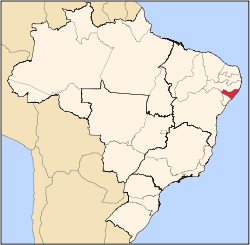 | |
| Palmeira dos Índios | ||
| Traipu | ||
| Litoral Norte Alagoano | ||
| Maceió | ||
| Mata Alagoana | ||
| Penedo | ||
| São Miguel dos Campos | ||
| Serrana dos Quilombos | ||
| Alagoana do Sertão do São Francisco | ||
| Batalha | ||
| Santana do Ipanema | ||
| Serrana do Sertão Alagoano | ||
This article is issued from
Wikipedia.
The text is licensed under Creative Commons - Attribution - Sharealike.
Additional terms may apply for the media files.