Piaçabuçu
| Piaçabuçu | |
|---|---|
| Municipality | |
| The Municipality of Piaçabuçu | |
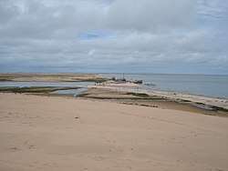 Base level of Rio São Francisco. | |
| Nickname(s): PBU | |
| Coordinates: 10°24′21″S 36°26′02″W / 10.40583°S 36.43389°WCoordinates: 10°24′21″S 36°26′02″W / 10.40583°S 36.43389°W | |
| Country |
|
| Region | Northeast |
| State |
|
| Founded | May 31, 1832 |
| Government | |
| • Mayor | Dalmo Moreira Santana Júnior (PSB) |
| Area | |
| • Total | 242.9 km2 (93.8 sq mi) |
| Elevation | 5 m (16 ft) |
| Population (2010) | |
| • Total | 25,080 |
| • Density | 82.0/km2 (212/sq mi) |
| [1] | |
| Time zone | UTC-3 |
| HDI (2000) | 0.613 – medium[2] |
Piaçabuçu is a municipality located in the Brazilian state of Alagoas. It is the southernmost municipality in Alagoas, and lies near both São Francisco River and the Atlantic Ocean. Its population was 17,980 (2008) and its area is 240 km².[3]
References
Capital: Maceió | ||
| Arapiraca | 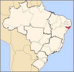 | |
| Palmeira dos Índios | ||
| Traipu | ||
| Litoral Norte Alagoano | ||
| Maceió | ||
| Mata Alagoana | ||
| Penedo | ||
| São Miguel dos Campos | ||
| Serrana dos Quilombos | ||
| Alagoana do Sertão do São Francisco | ||
| Batalha | ||
| Santana do Ipanema | ||
| Serrana do Sertão Alagoano | ||
This article is issued from
Wikipedia.
The text is licensed under Creative Commons - Attribution - Sharealike.
Additional terms may apply for the media files.