Qucha Quchayuq Urqu
| Qucha Quchayuq Urqu | |
|---|---|
 Qucha Quchayuq Urqu Location in Bolivia | |
| Highest point | |
| Elevation | 4,304 m (14,121 ft) [1]B |
| Coordinates | 17°32′54″S 65°31′33″W / 17.54833°S 65.52583°WCoordinates: 17°32′54″S 65°31′33″W / 17.54833°S 65.52583°W |
| Geography | |
| Location |
Bolivia, Cochabamba Department, Carrasco Province |
| Parent range | Andes |
Qucha Quchayuq Urqu (Quechua qucha lake, the reduplication indicates that there is a group or a complex of something, -yuq a suffix, urqu mountain,[2] "a mountain with many lakes", also spelled Khocha Khochayoj Orkho) is a 4,304-metre-high (14,121 ft) mountain in the Bolivian Andes. It is located in the Cochabamba Department, the Carrasco Province, Pocona Municipality, near the border with the Arani Province, Vacas Municipality. Qucha Quchayuq Urqu lies on a ridge east of Vacas, southwest of Rumi Rumiyuq.[1][3]
References
Capital: Cochabamba | ||
| Provinces | 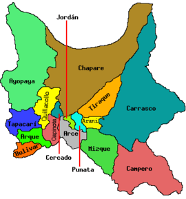 | |
| Municipalities (and seats) |
| |
This article is issued from
Wikipedia.
The text is licensed under Creative Commons - Attribution - Sharealike.
Additional terms may apply for the media files.