Carrasco Province
| Carrasco Province | |
|---|---|
| Province | |
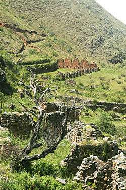 The UNESO World Heritage site of Inkallaqta in the Carrasco Province | |
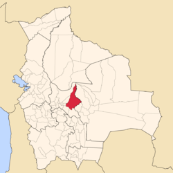 Location of the Carrasco Province within Bolivia | |
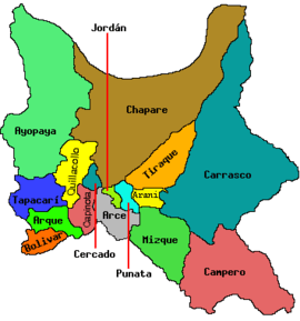 Provinces of the Cochabamba Department | |
| Coordinates: 17°20′0″S 65°20′0″W / 17.33333°S 65.33333°W | |
| Country |
|
| Department | Cochabamba Department |
| Municipalities | 6 |
| Cantons | 24 |
| Capital | Totora |
| Government | |
| • Mayor | Nicolas Rosas Jaldin |
| Area | |
| • Total | 5,809 sq mi (15,045 km2) |
| Population (2001) | |
| • Total | 116,205 |
| • Density | 20/sq mi (7.7/km2) |
| • Ethnicities | Quechua, Yuracaré |
Carrasco is a province in the Cochabamba Department in central Bolivia. Its capital is Totora.
Geography
Some of the highest mountains of the province are listed below:[1][2]
- Apachita
- Ch'uru Wayq'u
- Ch'utu Ch'utu
- Iskay Wasi
- Jatun Muqu
- Jatun Pampa
- Jatun Salla
- Juch'uy
- Lawayqu
- Layqa
- Machaqa Marka
- Mama Rumi
- Mama Wasi
- Misk'i
- Nina
- Putu Phutunqu
- P'isaqa
- P'ukru
- Qucha Qucha
- Qucha Quchayuq Urqu
- Qutani
- Rumi Rumiyuq
- Salla Punta
- Sallani
- Tawri
- T'utura
- Wasa Mayu
- Wathiya
- Yana Urqu
- Yuraq Qallpa
- Yuraq Yuraq
Subdivision
Carrasco Province is divided into six municipalities which are further subdivided into cantons.
| Section | Municipality | Inhabitants 2001 [3] | Seat | Inhabitants |
|---|---|---|---|---|
| 1st | Totora Municipality | 12,961 | Totora | 1,597 |
| 2nd | Pojo Municipality | 11,515 | Pojo | 786 |
| 3rd | Pocona Municipality | 13,488 | Pocona | 244 |
| 4th | Chimoré Municipality | 15,264 | Chimoré | 3,874 |
| 5th | Puerto Villarroel Municipality | 40,790 | Puerto Villarroel | 1,778 |
| 6th | Entre Ríos Municipality | 30,398 | Entre Ríos | 3,796 |
Entre Ríos Municipality was created in 2004.
The people
The people are predominantly indigenous citizens of Quechuan descent.[4] There are also groups of Yuracaré along Chapare River in the municipalities Chimoré and Puerto Villarroel.[5]
| Ethnic group | Totora Municipality (%) | Pojo Municipality (%) | Pocona Municipality (%) | Chimoré Municipality (%) | Puerto Villarroel Municipality (%) | Entre Ríos Municipality (%) |
|---|---|---|---|---|---|---|
| Quechua | 93.9 | 88.5 | 94.0 | 67.6 | 79.9 | 76.3 |
| Aymara | 0.7 | 0.5 | 0.2 | 5.1 | 3.1 | 3.8 |
| Guaraní, Chiquitos, Moxos | 0.9 | 0.0 | 0.1 | 2.0 | 1.1 | 1.6 |
| Not indigenous | 4.4 | 10.8 | 5.6 | 20.1 | 14.6 | 17.4 |
| Other indigenous groups | 0.1 | 0.2 | 0.9 | 5.1 | 1.3 | 0.9 |
Languages
The languages spoken in the Carrasco Province are mainly Quechua and Spanish. The following table shows the number of those belonging to the recognized group of speakers.[6]
| Language | Totora Municipality | Pojo Municipality | Pocona Municipality | Chimoré Municipality | Puerto Villarroel Municipality | Entre Ríos Municipality |
|---|---|---|---|---|---|---|
| Quechua | 11,671 | 10,203 | 12,482 | 9,596 | 29,940 | 14,789 |
| Aymara | 72 | 74 | 39 | 965 | 1,590 | 907 |
| Guaraní | 7 | 9 | 3 | 19 | 39 | 41 |
| Another native | 16 | 9 | 6 | 424 | 235 | 27 |
| Spanish | 4,967 | 4,991 | 4,954 | 11,530 | 29,377 | 17,164 |
| Foreign | 32 | 15 | 22 | 128 | 199 | 142 |
| Only native | 7,060 | 5,623 | 7,706 | 2,518 | 8,131 | 3,207 |
| Native and Spanish | 4,645 | 4,598 | 4,790 | 7,811 | 22,426 | 11,864 |
| Only Spanish | 322 | 393 | 166 | 3,726 | 6,956 | 5,314 |
Visitor attractions
Carrasco National Park and the archaeological site of Inkallaqta are situated within the province.
References
- ↑ Bolivia 1:100,000 Mizque 3835
- ↑ "Pocona". INE, Bolivia. Archived from the original on April 14, 2016. Retrieved April 7, 2016.
- ↑ www.ine.gob.bo Archived September 24, 2011, at the Wayback Machine.
- ↑ obd.descentralizacion.gov.bo
- ↑ www.amazonia.bo Archived 2011-02-09 at the Wayback Machine.
- ↑ obd.descentralizacion.gov.bo/departamental/fichas/ obd.descentralizacion.gov.bo
Coordinates: 17°20′S 65°20′W / 17.333°S 65.333°W
Capital: Cochabamba | ||
| Provinces | | |
| Municipalities (and seats) |
| |