Quillacollo Province
| Quillacollo Province | |
|---|---|
| Province | |
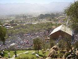 A view of the calvary of the Virgin of Urqupiña with pilgrims during the festival on August 16 | |
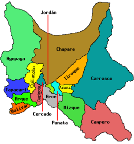
 Location of Quillacollo Province within Bolivia | |
 | |
| Coordinates: 17°20′S 66°15′W / 17.333°S 66.250°W | |
| Country |
|
| Department | Cochabamba Department |
| Municipalities | 5 |
| Cantons | 12 |
| Capital | Quillacollo |
| Government | |
| • Mayor | Hugo Cesar Miguel Candia (2007) |
| Area | |
| • Total | 280 sq mi (720 km2) |
| Population (2012) | |
| • Total | 336,615 |
| • Density | 1,210/sq mi (468/km2) |
| • Ethnicities | Quechua |
| Time zone | GMT -4 |
Quillacollo is a province in the Cochabamba Department, Bolivia. It is known for its festival in August where people from all over Bolivia come and pay homage to the Virgin of Urqupiña (Virgen de Urqupiña). Quillacollo is said to be one of the fastest growing cities in Bolivia.
Geography
One of the highest peaks of the province is Tunari at 5,023 m (16,480 ft). Other mountains are listed below:[1][2][3][4]
- Allqamari
- Asir Qullu
- Atuq Wachana
- Awila Wachana Punta
- Ch'uñawi
- Ichhu Apachita
- Inka Laqaya
- Jalsuri
- Janq'u Qala
- Jatun Kimray Punta
- Jatun Punta
- Jatun Q'asa
- Jukumarini
- Kimsa Tinkuy
- K'ayrani
- Llaqa K'uchu Punta
- Mamani Punta
- Nasa Q'ara
- Panti Pata
- Patilla Pata
- Pichaqani
- Pirwata
- Puka Salli
- Puka Waka
- Pukyu P'unqu
- Puma Apachita
- Phullu Punchu
- P'ukru Urqu
- P'utu P'utu
- Qillqata
- Qina Qina
- Qiñwa Q'asa
- Qiñwani
- Qullpani Punta
- Quna Quna Q'asa
- Q'ara Apachita
- Q'illu Suchusqa
- Rumi Q'asa
- Salla Q'asa
- Sankayuni
- Tikrasqa
- Tunari
- Turi Rumi
- T'ula Jayani Apachita
- Uqi Salli Punta
- Urqu Punta
- Wari Warini
- Wayna Tunari
- Wila Qullu Punta
- Wila Wila
- Wisk'achani
- Yana Qaqa
- Yarita Punta
- Yuraq Q'asa
- Yuraq Yaku
Subdivision
The province is divided into five municipalities which are further subdivided into cantons.
| Section | Municipality | Seat |
|---|---|---|
| 1st | Quillacollo Municipality | Quillacollo |
| 2nd | Sipe Sipe Municipality | Sipe Sipe |
| 3rd | Tiquipaya Municipality | Tiquipaya |
| 4th | Vinto Municipality | Vinto |
| 5th | Colcapirhua Municipality | Colcapirhua |
Languages
The languages spoken in the Quillacollo Province are mainly Spanish and Quechua. The following table shows the number of those belonging to the recognized group of speakers.[5]
| Language | Quillacollo Municipality | Sipe Sipe Municipality | Tiquipaya Municipality | Vinto Municipality | Colcapirhua Municipality |
|---|---|---|---|---|---|
| Quechua | 52,399 | 23,819 | 19,308 | 18,630 | 18,050 |
| Aymara | 7,101 | 1,127 | 2,481 | 2,259 | 2,449 |
| Guaraní | 101 | 24 | 43 | 38 | 38 |
| Another native | 82 | 24 | 36 | 26 | 46 |
| Spanish | 93,131 | 23,059 | 32,704 | 26,355 | 38,441 |
| Foreign | 2,087 | 215 | 1,100 | 403 | 1,136 |
| Only native | 5,756 | 6,544 | 2,972 | 3,332 | 1,365 |
| Native and Spanish | 50,157 | 17,704 | 17,737 | 16,680 | 18,139 |
| Only Spanish | 43,003 | 5,358 | 15,000 | 9,684 | 20,314 |
See also
References
- ↑ Bolivian IGM map 1:50,000 Quillacollo 6341-IV
- ↑ Bolivian IGM map 1:100,000 Quillacollo 3636
- ↑ "Sipe Sipe". INE, Bolivia. Archived from the original on March 29, 2016. Retrieved March 28, 2016.
- ↑ "Quillacollo". INE, Bolivia. Archived from the original on April 9, 2016. Retrieved March 31, 2016.
- ↑ obd.descentralizacion.gov.bo Archived February 18, 2009, at the Wayback Machine. (Spanish)
| Wikimedia Commons has media related to Quillacollo Province. |
Capital: Cochabamba | ||
| Provinces | | |
| Municipalities (and seats) |
| |
17°20′S 66°15′W / 17.333°S 66.250°WCoordinates: 17°20′S 66°15′W / 17.333°S 66.250°W