Orito
| Orito | |||
|---|---|---|---|
| Municipality and town | |||
| |||
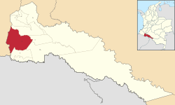 Location of the municipality and town of Orito in the Putumayo Department of Colombia. | |||
| Country |
| ||
| Department |
| ||
| Founded | 1963 | ||
| Government | |||
| • Mayor | Manuel Eduardo Ocoro Carabali | ||
| Area | |||
| • Municipality and town | 1,862.36 km2 (719.06 sq mi) | ||
| Elevation | 310 m (1,020 ft) | ||
| Population (2015) | |||
| • Municipality and town | 52,580 | ||
| • Density | 28/km2 (73/sq mi) | ||
| • Urban | 23,633 | ||
| Time zone | UTC-5 (Colombia Standard Time) | ||

.svg.png)
Orito is a town and municipality in the Putumayo Department, Republic of Colombia. The town is just south of the confluence of the Patascoy and Luzonyaco Rivers. It is 43 kilometres (27 mi) north of the border with Ecuador.
The town is served by Orito Airport.
Municipalities in the Putumayo Department | ||
|---|---|---|
Coordinates: 0°39′58″N 76°52′15″W / 0.66611°N 76.87083°W
This article is issued from
Wikipedia.
The text is licensed under Creative Commons - Attribution - Sharealike.
Additional terms may apply for the media files.