Pushpalal Mid Hill Highway
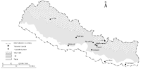
The Mid-Hills region in map of Nepal

A scene of Mid-Hill Highway in Baglung District during constitution
Pushpalal Mid-Hill Highway (Nepali: पुष्पलाल मध्य-पहाडी लोकमार्ग) is an ongoing road project in Nepal, which is thought to be 1,776 kilometres (1,104 mi) long.After completion,it will be the longest national highway of Nepal. Nepal has three geographical regions from east to west, plain land or Terai in south, higher mountains or Himalayas in north and hills in middle region. The highway runs through the mid-hills region only. It starts from easternmost hill at Chiyabhanjyang of Panchthar District (Province No. 1) and ends at westernmost hill at Jhulaghat of Baitadi District in far west (Province No. 7).[1][2]
See also
References
- ↑ "Mid-Hill Highway – 1776 km. of road from East to West!". localnepaltoday.com. 13 June 2015. Retrieved 16 October 2017.
- ↑ "New highway generates business opportunities in Baglung". Kantipur Publications. 5 March 2017. Retrieved 16 October 2017.
This article is issued from
Wikipedia.
The text is licensed under Creative Commons - Attribution - Sharealike.
Additional terms may apply for the media files.