Public transport in Athens
Public transport in Athens comprises a bus network, various rail systems, funiculars, and maritime services to serve the more than 4 million inhabitants of the city spread over an area of 2928 km².
Rail transport
Metro
.jpg)
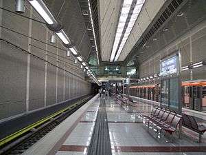
The Athens Metro is more commonly known in Greece as the Attiko Metro (Greek: Αττικό Mετρό) and provides public transport throughout the Athens Urban Area. While its main purpose is transport, it also houses Greek artifacts found during construction of the system.[1] The Athens Metro has an operating staff of 387 and runs two of the three metro lines; namely the Red (line 2) and Blue (line 3) lines, which were constructed largely during the 1990s, with the initial sections opened in January 2000. All routes run entirely underground and a fleet of 42 trains consisting of 252 cars operate within the network,[2] with a daily occupancy of 550,000 passengers.[2]
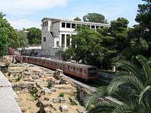
Line 1 (Electric Railway)
Line 1 (Electric Railway) now serves 24 stations, and forms the oldest line of the Athens metro network and for the most part runs at ground level,[3] connecting the port of Piraeus with the northern suburb of Kifissia. The line is set to be extended to Agios Stefanos, a suburb located 23 km (14 mi) to the north of Athens, reaching to 36 km (22 mi). Line 1 has a network length of 25.6 km (15.9 mi),[4] an operating staff of 730 and a fleet of 44 trains and 243 cars.[4] Line 1 occupancy rate is 600,000 passengers daily.[4] Line 1 used to be run by the separate company ISAP S.A., but since 2011, all the metro lines in Athens, are run by the new company STASY S.A.[5]
Line 2
Line 2 (the Red Line) runs from Anthoupoli to Elliniko and covers a distance of 17.5 km (10.9 mi).[2]
Line 3
Line 3 (the Blue Line) runs from the western suburbs, namely the Egaleo station, through the central Monastiraki and Syntagma stations to Doukissis Plakentias avenue in the northeastern suburb of Halandri, covering a distance of 16 km (10 mi),[2] then ascending to ground level and reaching Eleftherios Venizelos International Airport, using the Suburban Railway infrastructure and extending its length to 39 km (24 mi).[2] The spring 2007 extension from Monastiraki westwards, to Egaleo, connected some of the main night life hubs of the city, namely the ones of Gazi (Kerameikos station) with Psirri (Monastiraki station) and the city centre (Syntagma station). Extensions are under construction westwards to Piraeus.
Suburban rail (Proastiakos)
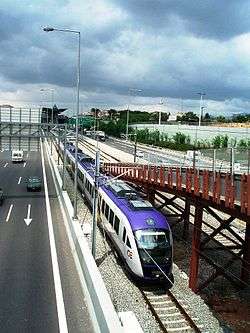
The Athens commuter rail service, referred to as the "Proastiakós", connects Eleftherios Venizelos International Airport to the city of Corinth, 80 km (50 mi)[6] west of Athens, and Larissa station, the city's central rail station, with the port of Piraeus and Chalkida The service is sometimes considered the fourth line of the Athens Metro. The length of Athens's commuter rail network extends to 120 km (75 mi),[6] and is expected to stretch to 281 km (175 mi) by 2010.[6] The Proastiakos will be extended to Xylokastro west of Corinth.[6]
Tram
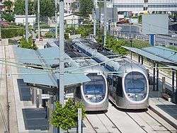
Athens Tram SA operates a fleet of 35 vehicles,[7] called 'Ansaldobreda Sirio',[8] which serve 48 stations,[7] employ 345 people with an average daily occupancy of 65,000 passengers.[7] The tram network spans a total length of 27 km (17 mi) and covers ten Athenian suburbs.[7] The network runs from Syntagma Square to the southwestern suburb of Palaio Faliro, where the line splits in two branches; the first runs along the Athens coastline toward the southern suburb of Voula, while the other heads towards Neo Faliro. The network covers the majority of the Saronic coastline.[9] Further extensions are planned towards the major commercial port of Piraeus.[7] The expansion to Piraeus will include 12 new stations, increase the overall length of tram route by 5.4 km (3 mi), and increase the overall transportation network.[10]
Railways and ferry connections
Athens is the hub of the country's national railway system (OSE), connecting the capital with major cities across Greece and abroad (Istanbul, Sofia and Bucharest). Due to financial difficulties, all international rail services were suspended indefinitely in 2011. The Port of Piraeus connects Athens to the numerous Greek islands of the Aegean Sea, with ferries departing, while also serving the cruise ships that arrive.
Road transport
Bus transport
OSY (Greek: ΟΣΥ) (Odikes SYgkinonies), or Road Transport, is the main operator of buses and trolleybuses in Athens. Its network consists of about 300 bus lines which span the Athens Metropolitan Area, with an operating staff of 5,327, and a fleet of 1,839 buses.Of those 1,839 buses 416 run on compressed natural gas,[11] making up the largest fleet of natural gas-powered buses in Europe.
Besides being served by a fleet of natural-gas and diesel buses, the Athens Urban Area is also served by trolleybuses — or electric buses, as they are referred to in the name of the operating company. The network consists of 22 lines with an operating staff of 1,137. All of the 366 trolleybuses are equipped to enable them to run on diesel in case of power failure.[12]
International and regional bus links are provided by KTEL from two InterCity Bus Terminals, Kifissos Bus Terminal A and Liosion Bus Terminal B, both located in the north-western part of the city. Kifissos provides connections towards the Peloponnese and Attica, whereas Liosion is used for most northerly mainland destinations.
Athens Public Transportation Statistics
The average amount of time people spend commuting with public transit in Athens, for example to and from work, on a weekday is 71 min. 16% of public transit riders, ride for more than 2 hours every day. The average amount of time people wait at a stop or station for public transit is 18 min, while 34% of riders wait for over 20 minutes on average every day. The average distance people usually ride in a single trip with public transit is 6.8 km, while 13% travel for over 12 km in a single direction. [13]
References
- ↑ "Athens Metro". Hellenic Ministry of Culture. www.culture.gr. Archived from the original on 7 December 2006. Retrieved 26 January 2007.
- 1 2 3 4 5 "Athens Urban Transport Network in Facts and Figures (pdf) page 15" (PDF). OASA. www.oasa.gr. Archived from the original (PDF) on June 29, 2006. Retrieved 4 February 2007.
- ↑ "ISAP – Athens Piraeus Electric Railways". Isap.gr. Archived from the original on 20 June 2009. Retrieved 9 June 2009.
- 1 2 3 "Athens Urban Transport Network in Facts and Figures (pdf) page 9" (PDF). OASA. www.oasa.gr. Archived from the original (PDF) on June 29, 2006. Retrieved 4 February 2007.
- ↑ "Urban Rail Transport SA :Urban Rail Transport S.A". stasy.gr (in Greek). Retrieved 2017-06-17.
- 1 2 3 4 "Proastiakos". www.proastiakos.gr. Archived from the original on July 21, 2009. Retrieved 9 June 2009.
- 1 2 3 4 5 "Tram Sa". Tramsa.gr. Archived from the original on 21 July 2011. Retrieved 25 October 2009.
- ↑ Athens - The Truth: Searching for Mános, Just Before the Bubble Burst. Tales of Orpheus. 1 September 2013. Retrieved 24 October 2013.
- ↑ "Athens Urban Transport Network in Facts and Figures (pdf) page 13" (PDF). OASA. www.oasa.gr. Archived from the original (PDF) on June 29, 2006. Retrieved 28 January 2007.
- ↑ "Tram Sa". Tramsa.gr. Archived from the original on 21 July 2011. Retrieved 25 October 2009.
- ↑ "Athens Urban Transport Network in Facts and Figures (pdf) page 6" (PDF). OASA. www.oasa.gr. Archived from the original (PDF) on June 29, 2006. Retrieved 28 January 2007.
- ↑ "Athens Urban Transport Network in Facts and Figures (pdf) page 11" (PDF). OASA. www.oasa.gr. Archived from the original (PDF) on June 29, 2006. Retrieved 28 January 2007.
- ↑ "Athens Public Transportation Statistics". Global Public Transit Index by Moovit. Retrieved June 19, 2017.
