Psathopyrgos
| Psathopyrgos Ψαθόπυργος | |
|---|---|
 | |
 Psathopyrgos | |
| Coordinates: 38°20′N 21°52′E / 38.333°N 21.867°ECoordinates: 38°20′N 21°52′E / 38.333°N 21.867°E | |
| Country | Greece |
| Administrative region | West Greece |
| Regional unit | Achaea |
| Municipality | Patras |
| Municipal unit | Rio |
| Elevation | 5 m (16 ft) |
| Population (2011)[1] | |
| • Rural | 663 |
| Community[1] | |
| • Population | 796 (2011) |
| Time zone | UTC+2 (EET) |
| • Summer (DST) | UTC+3 (EEST) |
| Postal code | 265 04 |
| Area code(s) | 261 |
| Vehicle registration | AX, AZ |
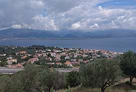
Psathopyrgos (Greek: Ψαθόπυργος)[2] is a tourist village and community in the municipal unit of Rio in the northern part of Achaea, Greece. Psathopyrgos is located on the Gulf of Corinth, south east of Cape Drepano, the northernmost point of the Peloponnese peninsula. The village has a small pebble beach and it is known to the locals and tourists for its fish taverns and nice views of the green mountains south of the village.
It is located 2 km north east of Drepano and 9 km north east of Rio. The Greek National Road 8A (Patras - Aigio - Corinth) pass south of the village. In the new railway line Athens-Corinth-Patras, which is currently under construction (June 2018), a railway stop is planned. The community Psathopyrgos consists of the villages Psathopyrgos and Kato Rodini.
Historical population
| Year | Population village | Population community |
|---|---|---|
| 1981 | 479 | - |
| 1991 | 550 | 669 |
| 2001 | 670 | 834 |
| 2011 | 663 | 796 |
See also
External links
References
- 1 2 "Απογραφή Πληθυσμού - Κατοικιών 2011. ΜΟΝΙΜΟΣ Πληθυσμός" (in Greek). Hellenic Statistical Authority.
- ↑ Psathopyrgos beach