Gulf of Corinth
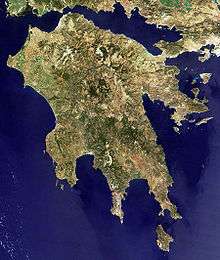
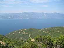
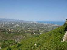
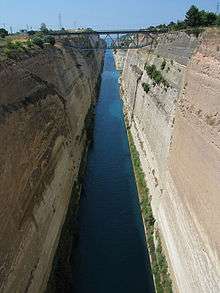
The Gulf of Corinth or the Corinthian Gulf (Greek: Κορινθιακός Kόλπος, Korinthiakόs Kόlpos, Greek pronunciation: [korinθʝaˈkos ˈkolpos]) is a deep inlet of the Ionian Sea separating the Peloponnese from western mainland Greece. It is bounded in the east by the Isthmus of Corinth which includes the shipping-designed Corinth Canal and in the west by the Strait of Rion which widens into the shorter Gulf of Patras (part of the Ionian Sea) and of which the narrowest point is crossed since 2004 by the Rio–Antirrio bridge. The gulf is bordered by the large administrative divisions (regional units): Aetolia-Acarnania and Phocis in the north, Boeotia in the northeast, Attica in the east, Corinthia in the southeast and south and Achaea in the southwest. The gulf is in tectonic movement comparable to movement in parts of Iceland and Turkey, growing by 10 mm (0.39 in) per year.
In medieval times, the gulf was known as the Gulf of Lepanto (the Italian form of Naupactus).
Shipping routes between the Greek commercial port Piraeus (further away from ultimate destinations but larger and better connected to the south than the north-western Greek port of Igoumenitsa) to western Mediterranean and hemisphere ports pass along this gulf. A further crossing in the form of ferry links Aigio and Agios Nikolaos, towards the western part of the gulf.
- Length: 130 km (81 mi)
- Width: 8.4 to 32 km (5.2 to 19.9 mi)
- Max Depth 935 m (3,068 ft)[1]
Geology
The gulf was created by the expansion of a tectonic rift due to the westward movement of the Anatolian Plate, and expands by 10 mm (0.39 in) per year.[2] The surrounding faults can produce earthquakes up to magnitude 6.8, though they are relatively uncommon. A large part of the northern margin of gulf is characterized by gentle gradients (between 10 and 20 degrees). The southern margin of the gulf is largely characterized by very steep gradients (between 30 and 40 degrees)[3].
Nature
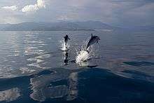
Cetaceans such as fin whales[4] or dolphins are known to come into the Corinthian gulf occasionally.[5]
Gulfs and bays
- Alkyonides Gulf, east
- Crissaean Gulf (Gulf of Crissa), north
- Bay of Antikyra, north
- Dombraina (Domvrena), north
- Strait of Rio, west
Islands
- Trizonia (the only inhabited), Alkyonides Islands (group of islets), Ampelos (islet), Fonias (islet), Prasoudi (islet)
Bridges
Cities and towns
The main cities and towns that lie next to the gulf are, from the northwest clockwise, and grouped by regional unit:
Tributaries
All tributaries are listed west to east.
Northern
Southern
- Selemnos
- Volinaios
- Foinikas
- Selinountas
- Vouraikos
- Krathis
- Krios
- Zacholitikos
- Fonissa
- Sythas
- Elissonas
- Asopos
References
- ↑ Thalassographica, Institute of Oceanographic and Fisheries Research, vol. 11-15, page 35, (1988)
- ↑ "Ambraseys, N.N. & Jackson, J.A. 1997. Seismicity and strain in the Gulf of Corinth (Greece) since 1694. Journal of earthquake engineering, 1, 433-474". Informaworld.com. 1970-01-01. Retrieved 2012-05-17.
- ↑ Frostick, L & Steel, Ronald. (2009). Tectonic Signatures in Sedimentary Basin Fills: An Overview. International Journal of Rock Mechanics and Mining Sciences & Geomechanics Abstracts. 31. 1-9.10.1002/9781444304053.ch1
- ↑ nefarius03 (19 May 2013). "Fin Whale in the Gulf of Korinth". Retrieved 13 April 2018 – via YouTube.
- ↑ Keep Talking Greece. 2011. Trapped Whale in Greece (video). Retrieved on November 6. 2014
External links
| Wikimedia Commons has media related to Gulf of Corinth. |