Provincetown Municipal Airport
| Provincetown Municipal Airport | |
|---|---|
 | |
| Summary | |
| Airport type | Public |
| Owner | U.S. National Park Service |
| Operator | Town of Provincetown |
| Serves | Provincetown, Massachusetts |
| Elevation AMSL | 9 ft / 3 m |
| Coordinates | 42°04′19″N 070°13′17″W / 42.07194°N 70.22139°W |
| Website | PVC Website |
| Map | |
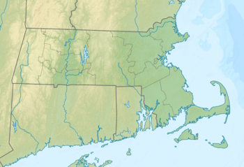 PVC Location of airport in Massachusetts / United States  PVC PVC (the US) | |
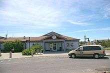
Provincetown Municipal Airport (IATA: PVC, ICAO: KPVC, FAA LID: PVC) is a public airport located at the end of Cape Cod, two miles (3 km) northwest of the central business district of Provincetown, in Barnstable County, Massachusetts, United States. This airport is operated by the Town of Provincetown on land leased from the U.S. National Park Service.[1]
The airport is used for general aviation and by one commercial airline, Cape Air, which operates non-stop flights of 25 minutes duration to Boston's Logan International Airport. During the off-season, Cape Air operates three daily flights each way. On summer weekends, flights are scheduled approximately every 45 minutes in both directions. The airport recently added complimentary high-speed internet access for all passengers and crew members utilizing the facility. A limited amount of free parking is available for vehicles used by general and commercial aviation passengers. Aircraft parking is available from Cape Air, the fixed-base operator (FBO).
Facilities and aircraft
Provincetown Municipal Airport covers an area of 310 acres (125 ha).
| Runway Information[2] | ||
|---|---|---|
| Dimensions | 3502 x 100 ft. / 1067 x 30m | |
| Surface | asphalt, in good condition. | |
| Weight Bearing Capacity | Single Wheel: 25.0 | |
| Runway Edge Lights | High Intensity | |
| Runway 7 | Runway 25 | |
| Latitude | 42-04.189783N | 42-04.484083N |
| Longitude | 070-13.576812W | 070-12.911400W |
| Elevation (MSL) | 7.6 ft | 7.8 ft |
| Traffic Pattern | Left | Right |
| Runway Heading | 075 magnetic
059 true |
255 magnetic
239 true |
| Markings | Precision, in good condition | Precision, in good condition |
| Visual Slope Indicator | 4-light PAPI on right (3.00 degrees glide path) | 4-light PAPI on right (3.00 degrees glide path)
VGSI and descent angle not coincident. |
| Approach Lights | MALSF: 1,400 foot medium intensity approach lighting system with sequenced flashers | none |
| Runway End Identifier Lights | Yes | Yes |
| Touchdown Point | Yes, no lights | Yes, no lights |
| Instrument Approach | ILS/DME, RNAV (GPS) | NDB, RNAV (GPS) |
| Obstructions | 12 ft. brush, 800 ft. from runway, 125 ft. left of centerline | 12 ft. trees, 610 ft. from runway, 125 ft. left of centerline, 34:1 slope to clear |
For 12-month period ending September 1, 2016, the airport averaged 136 operations per day: 85% transient general aviation, 8% commercial, 2% air taxi, 4% local general aviation and <1% military. There are 10 aircraft based at this airport: 8 single engine and 2 multi-engine.[2]
Airline and destinations
| Airlines | Destinations |
|---|---|
| Cape Air | Boston Seasonal: White Plains |
Ground transportation
Taxis are often available in front of the airport terminal, but it is wise to make reservations. The rate per person into Provincetown is $8. Rental cars are available at the airport in summer months only. In the summer months a shuttle bus service runs between the airport, race point beach and the town center, but does not serve guest houses or inns.
Airport management
The Provincetown Airport is overseen by the Airport Commission,[3] a 5-person board appointed by the Provincetown Board of Selectmen. The town also appoints an Airport Manager. Currently, the manager is Arthur "Butch" Lisenby.
References
- ↑ FAA Airport Master Record for PVC (Form 5010 PDF), retrieved 2007-03-15
- 1 2 "AirNav: KPVC - Provincetown Municipal Airport". www.airnav.com. Retrieved 2017-11-25.
- ↑ . Town of Provincetown http://www.provincetown-ma.gov/index.aspx?NID=111. Retrieved July 20, 2015. Missing or empty
|title=(help)
External links
- FAA Terminal Procedures for PVC, effective October 11, 2018
- Resources for this airport:
- FAA airport information for PVC
- AirNav airport information for KPVC
- ASN accident history for PVC
- FlightAware airport information and live flight tracker
- NOAA/NWS latest weather observations
- SkyVector aeronautical chart, Terminal Procedures