Prees, Shropshire
| Prees | |
|---|---|
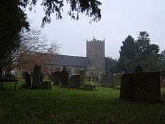 St Chad's church, Prees, dating from the 14th century, with an 18th-century tower | |
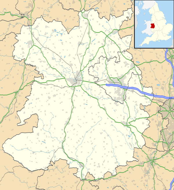 Prees Prees shown within Shropshire | |
| Population | 2,895 (2011 Census)[1] |
| OS grid reference | SJ553335 |
| Civil parish |
|
| Unitary authority | |
| Ceremonial county | |
| Region | |
| Country | England |
| Sovereign state | United Kingdom |
| Post town | WHITCHURCH |
| Postcode district | SY13 2 |
| Dialling code | 01948 |
| Police | West Mercia |
| Fire | Shropshire |
| Ambulance | West Midlands |
| EU Parliament | West Midlands |
| UK Parliament | |
Prees is a village and civil parish in north Shropshire, near the border between England and Wales. Its name is Celtic and means "brushwood".
The civil parish includes the smaller settlements of Sandford, Darliston, Fauls and Mickley to the east of the village.
Prees is northeast of the small town of Wem. It is also west of Market Drayton and south of Whitchurch. A number of nearby villages share the name Prees: Prees Village, Prees Green, Prees Heath and Prees Wood. All were formerly known as Prys - Wood or Prys, etc. The population in 2001 was recorded at 2688,[2] increasing to 2,895 as of the 2011 Census.
The church in the village dates back to the 14th century, however the tower is younger.
Also located in Prees is the Prees Church of England Primary School and Nursery, a Victorian building that holds much history.
Transport
Roads
Railway
West of the village of Prees, but not in the village or the parish as the name would suggest, is the railway station of Prees. It lies on the Welsh Marches Line, between Whitchurch and Wem. There is a regular service with pre-determined stops. The station is not in the village itself because Captain Black, a wealthy resident in the village stated that the station had to be exactly one mile away from the centre of the village, which at the time was the mill, located (still today) on Mill Street. This was so that it could be easily reached as a route out with the goods produced.

Canals
Prees was the intended destination of an arm of the Ellesmere Canal. However the arm was only completed as far as Quina Brook. The arm is now known as the Prees Branch of the Llangollen Canal, and is navigable for about a mile to Whixall Marina; the following 3/4 mile is still followable on the towpath as it passes through Prees Branch Canal Nature Reserve.[3]
Notable people
- James Fleetwood (c.1603-1683) an English clergyman, vicar of Prees and later Bishop of Worcester
- Thomas Gilbert (1613 in Prees – 1694) an English ejected minister of the seventeenth century.
- Philip Henry (1631–1696) an English Nonconformist clergyman [4] and diarist, ordained in Prees in 1657
- General Rowland Hill, 1st Viscount Hill GCB, GCH (1772 in Hawkstone Hall – 1842) as a British Army officer who served in the Napoleonic Wars. [5] His doric column stands in Shrewsbury.
- Sir Robert Chambre Hill CB Kt (1778 in Hawkstone Hall – 1860) a British Army cavalry officer, fought in the Peninsular War
- Major-General Clement Delves Hill (1781 in Hawkstone Hall – 1845) a British Army Officer who fought in the Battle of Waterloo
- Francis Sandford, 1st Baron Sandford KCB, PC (1824–1893) known as Sir Francis Sandford a British civil servant who implemented the Elementary Education Act of 1870, buried in Prees
- Sir Henry Maddocks KC (1871 in Prees — 1931) an English lawyer and Conservative Party politician
- Thomas Oakley (1879 in Prees – 1936) a British electrician and politician, MP for The Wrekin 1924-1929
- William Hutchings (1879 – 1948 in Prees) soldier and English amateur cricketer, played in 24 first-class matches for Kent and Worcs
Governance
An electoral ward in the same name exists. This ward stretches north-east to Adderley with a total ward population taken at the 2011 census of 4,281.[6]
References
- ↑ "Civil Parish population 2011". Retrieved 26 November 2015.
- ↑ http://www.shropshire.gov.uk/shropshire/factsfigures.nsf/viewAttachments/JMLE-7M8FL8/$file/P01_39UCGQ.htm
- ↑ Reserve Details Archived 2011-07-28 at the Wayback Machine.
- ↑ Dictionary of National Biography, 1885-1900, Volume 26, Henry, Philip retrieved 24th June 2018
- ↑ Dalton, Charles (1904). The Waterloo roll call. With biographical notes and anecdotes. London: Eyre and Spottiswoode. p. 13.
- ↑ "Ward population 2011". Retrieved 29 November 2015.
External links
![]()
| Unitary authorities | |
|---|---|
| Major settlements | |
| Rivers | |
| Canals | |
| Topics | |