Prata, Massa Marittima
| Prata | |
|---|---|
| Frazione | |
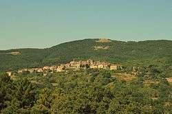 View of Prata | |
 Prata Location of Prata in Italy | |
| Coordinates: 43°04′59″N 10°59′07″E / 43.08306°N 10.98528°ECoordinates: 43°04′59″N 10°59′07″E / 43.08306°N 10.98528°E | |
| Country |
|
| Region |
|
| Province | Grosseto (GR) |
| Comune | Massa Marittima |
| Elevation | 620 m (2,030 ft) |
| Population (2011) | |
| • Total | 584 |
| Demonym(s) | Pratigiani |
| Time zone | UTC+1 (CET) |
| • Summer (DST) | UTC+2 (CEST) |
| Postal code | 58020 |
Prata is a village in Tuscany, central Italy, administratively a frazione of the comune of Massa Marittima, province of Grosseto, in the area of the Colline Metallifere. At the time of the 2001 census its population amounted to 559.[1]
Prata is about 48 km from Grosseto and 12 km from Massa Marittima, and it is a small medieval village (12th century) situated on a hill of Colline Metallifere.
Main sights
- Santa Maria Assunta, main parish church of the village, it was originally built as a pieve in the 12th century.
- Ruins of Cassero, a 13th-century fortress.
References
Bibliography
- Aldo Mazzolai, Guida della Maremma. Percorsi tra arte e natura, Le Lettere, Florence, 1997.
See also
| Wikimedia Commons has media related to Prata (Massa Marittima). |
This article is issued from
Wikipedia.
The text is licensed under Creative Commons - Attribution - Sharealike.
Additional terms may apply for the media files.