Roccastrada
| Roccastrada | ||
|---|---|---|
| Comune | ||
| Comune di Roccastrada | ||
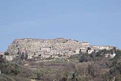 Panorama of Roccastrada | ||
| ||
 Roccastrada Location of Roccastrada in Italy | ||
| Coordinates: 43°0′N 11°10′E / 43.000°N 11.167°E | ||
| Country | Italy | |
| Region | Tuscany | |
| Province | Grosseto (GR) | |
| Frazioni | Montemassi, Piloni, Ribolla, Roccatederighi, Sassofortino, Sticciano, Torniella | |
| Government | ||
| • Mayor | Francesco Limatola (Partito Democratico) | |
| Area | ||
| • Total | 284.47 km2 (109.83 sq mi) | |
| Elevation | 475 m (1,558 ft) | |
| Population (30 November 2016)[1] | ||
| • Total | 9,198 | |
| • Density | 32/km2 (84/sq mi) | |
| Demonym(s) | Roccastradini | |
| Time zone | UTC+1 (CET) | |
| • Summer (DST) | UTC+2 (CEST) | |
| Postal code | 58036 | |
| Dialing code | 0564 | |
| Patron saint | St. Nicholas | |
| Saint day | 6 December | |
| Website | Official website | |

Roccastrada is a comune (municipality) in the Province of Grosseto in the Italian region Tuscany, located about 90 kilometres (56 mi) south of Florence and about 25 kilometres (16 mi) north of Grosseto, between the Maremma plain and the Colline Metallifere.
References
External links
| Wikimedia Commons has media related to Roccastrada. |
This article is issued from
Wikipedia.
The text is licensed under Creative Commons - Attribution - Sharealike.
Additional terms may apply for the media files.