Castiglione della Pescaia
| Castiglione della Pescaia | |
|---|---|
| Comune | |
| Comune di Castiglione della Pescaia | |
 | |
 Castiglione della Pescaia Location of Castiglione della Pescaia in Italy | |
| Coordinates: 42°45′N 10°52′E / 42.750°N 10.867°E | |
| Country | Italy |
| Region | Tuscany |
| Province | Grosseto (GR) |
| Frazioni | Ampio, Buriano, Macchiascandona, Pian d'Alma, Pian di Rocca, Ponti di Badia, Punta Ala, Riva del Sole, Roccamare, Rocchette, Tirli, Vetulonia |
| Government | |
| • Mayor | Giancarlo Farnetani |
| Area | |
| • Total | 209.28 km2 (80.80 sq mi) |
| Elevation | 4 m (13 ft) |
| Population (31 December 2017) | |
| • Total | 7,289 |
| • Density | 35/km2 (90/sq mi) |
| Demonym(s) | Castiglionesi |
| Time zone | UTC+1 (CET) |
| • Summer (DST) | UTC+2 (CEST) |
| Postal code | 58043 |
| Dialing code | 0564 |
| Patron saint | St. William of Aquitania |
| Saint day | 2 May |
| Website | Official website |
Castiglione della Pescaia ([kastiʎˈʎoːne della pesˈkaːja]), regionally simply abbreviated as Castiglione, is an ancient seaside town in the province of Grosseto, in Tuscany, central Italy. The modern city grew around a medieval fortress (Italian: castello) and a large fishery, from which it acquired its designation. Today Castiglione is a tourist destination thanks to its beaches, its fortress and the natural reserve Diaccia Botrona, a swampy humid environment whose wildlife include flamingoes, mallards and ducks. In 2014 it ranked 4th among the most visited destinations in Tuscany,[1] with approximately 1.3 million tourist arrivals, only preceded by Florence, Pisa and Montecatini Terme.
In 2015 Castiglione's sea was nominated as Italy's best sea by the national non-governmental environmentalist organisation Legambiente. [2]
Geography

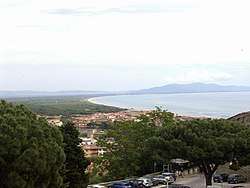
Castiglione della Pescaia consists of a High City built on the hill that ends a chain of hills towards the sea, and of a Low City at the foot of the former, straddling the drainage canal and marina that form the central part of town.
Castiglione is located in the South-Western portion of Tuscany, with a view of the islands of Elba and Giglio, and of the promontory of Argentario. The hills that back the city slope into beaches that front the town in its entirety.
To the East of Castiglione is the rich floodplain of the Ombrone river. Nothing much remains of the ancient lake Prile that used to be Castiglione's lifeblood.
History
While Umbrians and Etruscans were most likely the first inhabitants of its location, Castiglione della Pescaia was first recorded under the name Salebrone in Roman times. The hill close to the coast proved to be an excellent location, as it dominated the sizable inland Prelius Lake, while the lake itself provided food (fish) and trading goods (salt).
In the Middle Ages, the city suffered from repeated pirate attacks and almost disappeared. It resurfaced in the 9th century AD under its current name, under joint protection of the Papacy and the Republic of Pisa.
The Pisans used Castiglione as a key element in their system of defence along the Tyrrhenian coast. They built first a single tower on top of the hill, later expanded that to three towers joined by a wall that became the nucleus of the citadel. The three towers of Castiglione dominate the city seal to this day.
In the 13th century, Castiglione became an independent comune. Meanwhile, the river Ombrone had started silting up Lake Prile, which soon became a lagoon. In this newformed lagoon, malaria mosquitoes took hold, weakening the population of Castiglione. The city requested protection from various powers (Siena, the Medici, Aragon) and finally became part of the Grand Dukedom of Tuscany under the dynasty of Lorraine.
The house of Lorraine started a series of projects that greatly enhanced the lives of Castiglionesi. The swamps were drained over decades, increasing the amount of arable land, as well as killing off the malaria carrying mosquitoes.
After Tuscany became part of Italy in 1859, Castiglione became a comune in the province of Grosseto.
Main sights
One of the most popular tourist destinations in the area is the historical Etruscan centre of Vetulonia, which hosts an Etruscan museum with an adjacent well preserved archaeological site, encompassing ancient remains of the old inhabitants of Maremma. Furthermore, the hamlets of Punta Ala, Riva del Sole, Roccamare and Rocchette are beach resorts catering mostly tourists from Central and Northern Europe.
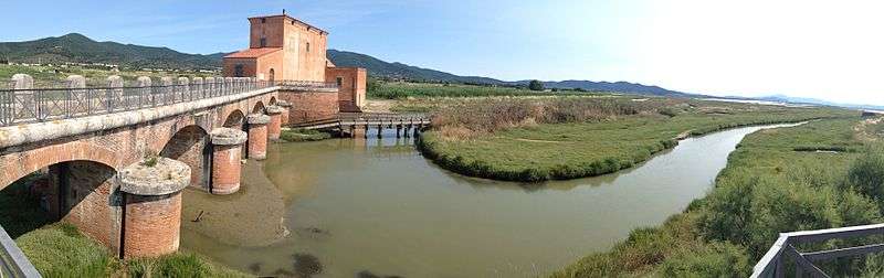
In the territory of Castiglione della Pescaia, the 1,000-hectare (2,500-acre) Natural Reserve of Diaccia Botrona (with 18th-century Casa Rossa Ximenes) is a designated wetland area of international interest, according to the Ramsar Convention.
References
External links
| Wikimedia Commons has media related to Castiglione della Pescaia. |