Postřelmůvek
| Postřelmůvek | |||
|---|---|---|---|
| Municipality | |||
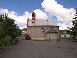 Chapel | |||
| |||
 Postřelmůvek | |||
| Coordinates: 49°55′39″N 16°52′0″E / 49.92750°N 16.86667°ECoordinates: 49°55′39″N 16°52′0″E / 49.92750°N 16.86667°E | |||
| Country |
| ||
| Region | Olomouc | ||
| District | Šumperk | ||
| Area | |||
| • Total | 4.01 km2 (1.55 sq mi) | ||
| Elevation | 322 m (1,056 ft) | ||
| Population (2006) | |||
| • Total | 339 | ||
| • Density | 85/km2 (220/sq mi) | ||
| Postal code | 789 01 | ||
| Website | http://postrelmuvek.zabrezsko.cz | ||

Postřelmůvek (German: Klein Heilendorf) is a village and municipality (obec) in Šumperk District in the Olomouc Region of the Czech Republic.
The municipality covers an area of 4.01 square kilometres (1.55 sq mi), and has a population of 339 (as at 28 August 2006).
Postřelmůvek lies approximately 9 kilometres (6 mi) south-west of Šumperk, 47 km (29 mi) north-west of Olomouc, and 176 km (109 mi) east of Prague.
References
| Wikimedia Commons has media related to Postřelmůvek. |
This article is issued from
Wikipedia.
The text is licensed under Creative Commons - Attribution - Sharealike.
Additional terms may apply for the media files.