Petrov nad Desnou
| Petrov nad Desnou | |||
|---|---|---|---|
| Municipality | |||
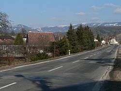 Road no. 11 going through Petrov. Hrubý Jeseník mountain range in the background. | |||
| |||
 Petrov nad Desnou | |||
| Coordinates: 50°0′24″N 17°2′33″E / 50.00667°N 17.04250°ECoordinates: 50°0′24″N 17°2′33″E / 50.00667°N 17.04250°E | |||
| Country |
| ||
| Region | Olomouc | ||
| District | Šumperk | ||
| Area | |||
| • Total | 12.20 km2 (4.71 sq mi) | ||
| Elevation | 365 m (1,198 ft) | ||
| Population (2010) | |||
| • Total | 1,242 | ||
| • Density | 100/km2 (260/sq mi) | ||
| Postal code | 788 14 to 788 16 | ||
| Website | http://www.obec.petrovnaddesnou.cz | ||
Petrov nad Desnou (German: Petersdorf an der Tess) is a village and municipality (obec) in Šumperk District in the Olomouc Region of the Czech Republic.
The municipality covers an area of 12.20 square kilometres (4.71 sq mi), and has a population of 1,242 (as at 1 January 2010).
Petrov nad Desnou lies approximately 7 kilometres (4 mi) north-east of Šumperk, 48 km (30 mi) north-west of Olomouc, and 189 km (117 mi) east of Prague.
From 1980 to 2009 the village was part of the municipality Sobotín. On 1 January 2010 Petrov nad Desnou separated from the municipality of Sobotín.
References
| Wikimedia Commons has media related to Petrov nad Desnou. |
This article is issued from
Wikipedia.
The text is licensed under Creative Commons - Attribution - Sharealike.
Additional terms may apply for the media files.