Portacomaro
| Portacomaro | ||
|---|---|---|
| Comune | ||
| Comune di Portacomaro | ||
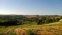 A hilly area near Portacomaro. | ||
| ||
 Portacomaro Location of Portacomaro in Italy | ||
| Coordinates: 44°57′27″N 8°15′30″E / 44.9574°N 8.2582°ECoordinates: 44°57′27″N 8°15′30″E / 44.9574°N 8.2582°E | ||
| Country | Italy | |
| Region | Piedmont | |
| Province | Asti (AT) | |
| Frazioni | Migliandolo | |
| Government | ||
| • Mayor | Valter Vittorio Antonio Petrini | |
| Area | ||
| • Total | 10.9 km2 (4.2 sq mi) | |
| Elevation | 232 m (761 ft) | |
| Population (30 July 2016)[1] | ||
| • Total | 2,017 | |
| • Density | 190/km2 (480/sq mi) | |
| Time zone | UTC+1 (CET) | |
| • Summer (DST) | UTC+2 (CEST) | |
| Postal code | 14037 | |
| Dialing code | 0141 | |
Portacomaro is a comune (municipality) in the Province of Asti in the Italian region Piedmont, located about 45 kilometres (28 mi) southeast of Turin and about 7 kilometres (4 mi) northeast of Asti.
Portacomaro borders the following municipalities: Asti, Calliano, Castagnole Monferrato, and Scurzolengo.
Main sights
Well-preserved apsidal frescos[2] can be found in the romanesque church of St. Peter [3] (first recorded in 1130 AD).[4] Formerly occupied by a monastic community, the chancel sides are decorated with figures of St. Bernard and St. Sebastian. The central section of tripartite rear wall of the sanctuary (probably the oldest) features a deisis (Crucifixion with Virgin and the beloved disciple, St. John), figures of St. Andrew are to the right, St. Agatha (kneeling) and St Peter to the left.
People
- Valerio Arri, Olympic marathoner
- Mario José Bergoglio, father of Pope Francis
References
- ↑ All demographics and other statistics: Italian statistical institute Istat.
- ↑ St Peter with keys stands to the right of altar apse fresco
- ↑ Tourist information page of the local Municipal Government of Portacomaro (current custodians of the historic cemetery and deconsecrated chapel)
- ↑ Architectural cut-away sketch of Chiesa di San Pietro, online feature at Valle versa de Astigianta website
