Montafia
| Montafia | ||
|---|---|---|
| Comune | ||
| Comune di Montafia | ||
| ||
 Montafia Location of Montafia in Italy | ||
| Coordinates: 44°59′N 8°1′E / 44.983°N 8.017°ECoordinates: 44°59′N 8°1′E / 44.983°N 8.017°E | ||
| Country | Italy | |
| Region | Piedmont | |
| Province | Province of Asti (AT) | |
| Area | ||
| • Total | 14.6 km2 (5.6 sq mi) | |
| Population (Dec. 2004) | ||
| • Total | 986 | |
| • Density | 68/km2 (170/sq mi) | |
| Time zone | UTC+1 (CET) | |
| • Summer (DST) | UTC+2 (CEST) | |
| Postal code | 14014 | |
| Dialing code | 0141 | |

Montafia is a comune (municipality) in the Province of Asti in the Italian region Piedmont, located about 25 kilometres (16 mi) southeast of Turin and about 15 kilometres (9 mi) northwest of Asti. As of 31 December 2004, it had a population of 986 and an area of 14.6 square kilometres (5.6 sq mi).[1]
Montafia borders the following municipalities: Buttigliera d'Asti, Capriglio, Cortazzone, Piea, Piovà Massaia, Roatto, San Paolo Solbrito, Viale, and Villanova d'Asti.
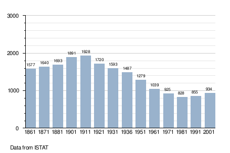
Demographic evolution
References

This article is issued from
Wikipedia.
The text is licensed under Creative Commons - Attribution - Sharealike.
Additional terms may apply for the media files.