Lochiel, South Australia
| Lochiel South Australia | |||||||||||||||
|---|---|---|---|---|---|---|---|---|---|---|---|---|---|---|---|
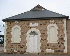 Public hall at Lochiel | |||||||||||||||
 Lochiel | |||||||||||||||
| Coordinates | 33°56′S 138°9′E / 33.933°S 138.150°ECoordinates: 33°56′S 138°9′E / 33.933°S 138.150°E | ||||||||||||||
| Population | 168 (2006 census)[1] | ||||||||||||||
| Postcode(s) | 5510 | ||||||||||||||
| Location | 125 km (78 mi) north of Adelaide | ||||||||||||||
| LGA(s) | Wakefield Regional Council | ||||||||||||||
| State electorate(s) | Narungga[2] | ||||||||||||||
| Federal Division(s) | Grey | ||||||||||||||
| |||||||||||||||
Lochiel is a small town in the Mid North of South Australia 125 km north of Adelaide. The town lies beside on the western edge of Lake Bumbunga and at the eastern foot of the Hummocks Range. The Augusta Highway, a section of Highway 1, runs on a strip between the township and the lake, which dwarves the former.
Name
Lochiel was the name given by Governor James Fergusson to the site of the planned Government Town of Lochiel in 1869. Lochiel is the traditional name used by chiefs of Clan Cameron (Lochiel being in the Hundred of Cameron named for a pioneer, Hugh Cameron). This is considered to be the a possible source of the name for the town.[3] Other possibilities are Loch Eil, a fjord in the home area of Clan Cameron, Lochiel the home of 1700s Clan Cameron chief Donald Cameron of Lochiel, or, with slightly different spelling, the Locheil Forest[4] near Fort William and also close to Loch Eil. It is possible that Lake Bumbunga, next to the townsite, reminded Governor Fergusson of the Scottish loch and he named the town to match.
History
The Government Town of Lochiel was surveyed in 1869, closely following the proclamation of the cadastral Hundred of Cameron, in which the town lies, by Governor James Fergusson.[3] In 1888 the township and the rest of the Hundred of Cameron was declared a part of the District Council of Port Wakefield by the District Councils Act 1887. The following year, due to resident lobbying, the Hundred of Cameron was moved from the control of Wakefield council into the hands of the District Council of Snowtown, cementing a close relationship between Lochiel and Snowtown rather than the more distant Port Wakefield.
In 1976, the secessionist micronation, the Province of Bumbunga, was declared by a local resident located on a farm at Bumbunga, just east of Lochiel. By 1999 the seceded province no longer existed and it is unclear whether there was ever any legal recognition of the resident's claim.
The town boundaries were formalised in 2000 with a small adjustment being made in 2007 to annex an eastern strip of Ninnes that had been within the same local council as Lochiel (Wakefield Regional Council) instead of the council governing the rest of Ninnes (District Council of Barunga West).[3]
Governance
Since 1997, local governance of the town has fallen under the control of the much larger Wakefield Regional Council. Prior to this, the town was locally governed by the District Council of Blyth-Snowtown. The town lies in the state electoral district of Nurangga and in the federal electoral division of Grey.
Economy
Salt has been mined at the nearby Lake Bumbunga salt extraction works since 1912.[5]
The Lochiel Coal Mine was operational a few kilometres east of the lake in the 1980s and 1990s.
Attractions
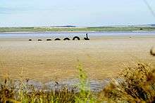
The town is host to the 'Loch Eel', an artistic creation of rubber tyres and plastic which was created by local Gary Taylor and friends in 1972. The "eel" is located in the Bumbunga lake beside the main highway.
References
- ↑ Australian Bureau of Statistics (25 October 2007). "Lochiel (Urban Centre/Locality)". 2006 Census QuickStats. Retrieved 2008-10-24.
- ↑ Narungga (Map). Electoral District Boundaries Commission. 2016. Retrieved 1 March 2018.
- 1 2 3 "Plcaename Details: Lochiel". Property Location Browser. Land Services, Government of South Australia. 4 March 2010. Retrieved 25 October 2016.
Other Details: Town was surveyed September 1869, no proclamation. Lochiel is one of the titles of the Chief of Clan Cameron, and as the town is located in the Hundred of Cameron, it is possible there is some connection (Cockburn). Boundaries created in January 2000 for long established name. Portion within Wakefield Regional Council excluded from Ninnes and included into Lochiel following a request from residents in January 2007. Incorporates the Government Town of Lochiel.
- ↑ Manning, Geoffrey. "Lochiel". Manning Index of South Australian History. Retrieved 25 October 2017.
Governor Fergusson named it after Scottish associations, (there is a 'Lochiel Forest' near Inverness). It is also one of the titles of the chief of the Cameron Clan, while the Scottish 'Lochiel' comes from the Gaelic ial - 'gleam of sunshine'.
- ↑ "Salt production in South Australia - Lochiel]". Primary Industries and Resources South Australia (PIRSA). Archived from the original on 12 July 2009.
External links
| Wikimedia Commons has media related to Lochiel, South Australia. |