Snowtown, South Australia
| Snowtown South Australia | |||||||||||||||
|---|---|---|---|---|---|---|---|---|---|---|---|---|---|---|---|
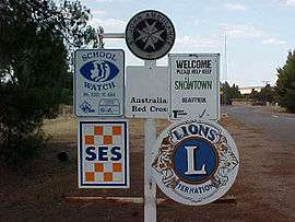 South-western entrance to Snowtown | |||||||||||||||
 Snowtown | |||||||||||||||
| Coordinates | 33°47′0″S 138°12′0″E / 33.78333°S 138.20000°ECoordinates: 33°47′0″S 138°12′0″E / 33.78333°S 138.20000°E | ||||||||||||||
| Population |
| ||||||||||||||
| Established | 1878 | ||||||||||||||
| Postcode(s) | 5520 | ||||||||||||||
| Elevation | 103 m (338 ft) | ||||||||||||||
| Location | 145 km (90 mi) north of Adelaide | ||||||||||||||
| LGA(s) | Wakefield Regional Council | ||||||||||||||
| State electorate(s) | Narungga[3] | ||||||||||||||
| Federal Division(s) | Grey | ||||||||||||||
| |||||||||||||||
| |||||||||||||||
Snowtown is a town located in the Mid North of South Australia 145 km (90 miles) north of Adelaide and lies on the main road and rail routes between Adelaide and Perth — the Augusta Highway and Adelaide-Port Augusta railway line. The town's elevation is 103 metres (338 feet) and on average the town receives 389 mm of rainfall per annum.
History
The settlement of Snowtown by non-indigenous Australians initially grew up around a railway station on the Brinkworth-Wallaroo line. Located on what was traditionally the land of the Kaurna (indigenous) people, the first pioneers arrived sometime between 1867 and 1869 due to the rapid expansion of farming to the north of the area. During this period one of the first major structures, the old Snowtown Pub was built in 1868. Bailliere's South Australian gazetteer and road guide, published in 1866, contains a brief description of "Hummock's Run" located 28 miles (45 km) north of Port Wakefield. This farmland, according to the publication, contained the farming stations of Barunga, Bumbunga and Wokurna and consisted of "salt lakes and lagoons, dense scrub, with mallee, pine and bushes, grassy plains and saltbush, well grassed spurs and hills, with oaks and wattle on the Broughton River."[4]
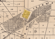
The Government only started showing interest in the settlement as late as 1869 when it planned to establish various new towns throughout the district and to divide the land into much smaller holdings. Snowtown's charter as a government town was proclaimed on 19 December 1878 by Governor William Jervois.[5] Jervois named the town after one of the members of the Snow family who were his cousins and lived on Yorke Peninsula (which lies immediately west and southwest of Snowtown). It is officially considered that the town was named after Thomas Snow,[6] who became Jervois's aide de camp when he received his posting in South Australia. The town boundaries were defined as an approximate rectangle immediately adjacent to section 114 in the Hundred of Barunga north east of Barunga Creek, north west of Salt Lagoon and south of Boundary Creek.[7]
In 1888 the District Council of Snowtown was established by proclamation of the District Councils Act 1887,[8] along with 20 other new local government bodies in South Australia. The new council incorporated the entirety of the hundreds of Barunga and Boucaut.
Bumbunga Province
During the 1970s and 1980s, the secessionist micronation of Bumbunga Province existed on farmland owned by the Brackstone family, 15 kilometres (9.3 mi) south of Snowtown.
Snowtown murders
In 1999, Snowtown became notorious as the location where the remains of eight bodies were found in barrels of acid stored in a disused bank vault. The Snowtown murders or Bodies in Barrels murders, as they came to be known, occurred in several locations in South Australia between August 1992 and May 1999. The bodies were held at a series of locations around Adelaide for some time, and were moved to Snowtown in early 1999, a few months before their discovery.
Only one victim was killed in Snowtown and none of the victims or the perpetrators were local to the town. Most of the murders had actually been committed in the outer northern suburbs of Adelaide, located on the outskirts of the South Australian capital.
Four people, including ringleader John Justin Bunting, were convicted of murder or assisting the murders. Snowtown, a film about the murders and the life of Bunting, was released in 2011.
Geography and climate
Snowtown is situated approximately 7 kilometres east of Barunga Gap, a cleft between the Barunga and Hummocks ranges. The excess rainfall from these hills collects in Lake Bumbunga, directly south of the township, and in a trail of smaller lakes stretching north of the town to Lake View near the main highway and railway line. Beyond the eastern edge of the township is the Snowtown Golf Course and a swampy region populated by saltbush and other salt-tolerant flora.
Snowtown has a warm Mediterranean climate with average summer temperatures around 30 °C and winter temperatures around 16 °C. The average annual rainfall is 407.4 millimetres (16.04 in), most of which falls in the winter months.[9]
| Climate data for Snowtown | |||||||||||||
|---|---|---|---|---|---|---|---|---|---|---|---|---|---|
| Month | Jan | Feb | Mar | Apr | May | Jun | Jul | Aug | Sep | Oct | Nov | Dec | Year |
| Record high °C (°F) | 46.3 (115.3) |
44.6 (112.3) |
43.0 (109.4) |
39.6 (103.3) |
31.7 (89.1) |
26.7 (80.1) |
27.7 (81.9) |
30.3 (86.5) |
34.4 (93.9) |
40.0 (104) |
43.9 (111) |
45.0 (113) |
46.3 (115.3) |
| Average high °C (°F) | 31.1 (88) |
30.8 (87.4) |
28.6 (83.5) |
23.6 (74.5) |
19.4 (66.9) |
16.2 (61.2) |
15.4 (59.7) |
16.7 (62.1) |
19.7 (67.5) |
23.2 (73.8) |
26.7 (80.1) |
29.2 (84.6) |
23.3 (73.9) |
| Average low °C (°F) | 14.6 (58.3) |
14.7 (58.5) |
12.7 (54.9) |
9.9 (49.8) |
7.8 (46) |
6.0 (42.8) |
5.2 (41.4) |
5.6 (42.1) |
6.7 (44.1) |
8.6 (47.5) |
11.1 (52) |
13.2 (55.8) |
9.7 (49.5) |
| Record low °C (°F) | 3.8 (38.8) |
2.8 (37) |
0.0 (32) |
−1.1 (30) |
−2.0 (28.4) |
−3.9 (25) |
−4.4 (24.1) |
−3.1 (26.4) |
−2.2 (28) |
−1.7 (28.9) |
0.6 (33.1) |
2.2 (36) |
−4.4 (24.1) |
| Average rainfall mm (inches) | 18.6 (0.732) |
19.0 (0.748) |
17.3 (0.681) |
29.8 (1.173) |
44.4 (1.748) |
52.4 (2.063) |
49.7 (1.957) |
50.2 (1.976) |
43.2 (1.701) |
37.6 (1.48) |
24.8 (0.976) |
20.4 (0.803) |
407.4 (16.038) |
| Average rainy days (≥ 0.2mm) | 3.5 | 3.4 | 4.0 | 7.0 | 10.4 | 12.5 | 13.4 | 13.5 | 10.9 | 9.2 | 6.0 | 4.7 | 98.5 |
| Source: Bureau of Meteorology[9] | |||||||||||||
Governance
The town administration now falls under the control of the Wakefield Regional Council for local governance. This body came into effect on 1 July 1997 as a result of the amalgamation of the former councils of Blyth-Snowtown and Wakefield Plains.
Snowtown lies in the state electoral district of Narungga and in the federal electoral division of Grey.
Media
Snowtown was home to a weekly newspaper called the Broughton Star (5 March 1909 – 5 July 1912) which was founded by James Barclay.[10] The newspaper was "continued" by Barclay, although it was in fact absorbed by another of his publications, the Stanley Herald (a reference to the electorate of Stanley), which he had also started in March 1909. The merged newspaper ran until 26 June 1941, at which point publication stopped due to wartime restrictions. Publication of the Herald resumed on 11 December 1947 for a little over a year at which point post-war labour shortages halted production on 16 December 1948.
Economy

Located in what is described as a wheat-belt, the local Snowtown economy is predominantly based on cereal crops. Other primary industries include woolgrowing, livestock production and salt mining (at the nearby Lake Bumbunga saltworks).[11]
Snowtown is a service centre for the local area, providing various essential services for the district as well as for motorists on the Augusta Highway, the section of Highway 1 past the town. Snowtown is known all over South Australia for its fresh curries at the service station.[12] Snowtown has therefore become a South Australian tradition for a stop on the road from Adelaide to Port Augusta where visitors will have a curry at the roadhouse which is now seen as one of Snowtown's main tourist attractions.[13]
In 2008, TrustPower completed the first stage of the 47-turbine Snowtown Wind Farm in the Barunga and Hummocks ranges just west of Snowtown. The wind turbines are 110 metres from the ground to tip of the top wing.[14]
Built environs
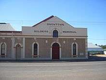
The town's main street, Fourth Street contains most of the town's civic buildings, notably the Snowtown Memorial Hall (built 1919) which is attached to the Old Institute (built 1889). Nearby is the town's tribute to the original pioneers telling visitors that the town's population is 520.
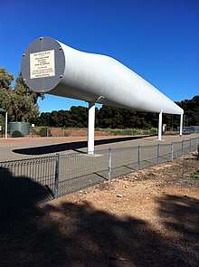
In 2008, a monument in the form of a 44-metre wind turbine blade was installed at the intersection of Fourth Street and Railway Terrace East.[15]
Attractions
Snowtown's main attraction is as the 'curry stop' on highway one due to being renowned as a 'South Australian institution' and tourist drawcard for its Indian Cuisine at the 100 Mile Roadhouse.[16]
Transport
The main north-south road running just outside the western edge of the town was designated to form part of Australia's Highway 1 in 1955. The section passing Snowtown (from Port Wakefield to Port Augusta) was named Augusta Highway in 2011.
The Brinkworth–Kadina railway line opened in 1879. It connected Snowtown via Bute to the port of Wallaroo, initially built as narrow gauge. This line was converted to broad gauge in 1927, but closed following the gauge standardisation of the Adelaide-Crystal Brook line in 1982.
The Salisbury-Redhill broad railway gauge line was opened in 1925 and intersected the town along a north-south axis. In 1982 the line was converted to standard gauge, making it a part of the Adelaide-Port Augusta railway line.
School
In 1879 Mrs Lamb opened a Provisional School in Snowtown with a total enrolment of 14 pupils. During its lifetime agricultural science has been a particular focus for the school.[17][18]
In 1961 the school became an area school known as Snowtown Area School and was located on 4.5 hectares (11 acres) of land, with an additional 10 hectares (25 acres) of land used for agricultural studies.
In the 1970s and 1980s, the school's respected agricultural credentials drew students from neighbouring communities.[18] The school provided many entries into Royal Adelaide Show livestock and horticulture competitions, especially the sheep and beef cattle categories. In the early 1980s the school became a poll dorset sheep stud called 'SASdor' for several years.[18]
Pupil enrolments at Snowtown Area School in 2006 totalled 118, with many pupils also travelling from nearby Lochiel, Barunga Gap and Redhill. As of 2006 pupils were also able to study via distance education through the Open Access College at Marden (Adelaide) or via larger neighbouring schools to increase their range of subject choices.
By 2012, the fall in enrolments, and consequent drop in funding, led to the ceasing of senior enrolments at the commencement of the 2013 school year. The school was subsequently renamed to Snowtown Primary School.[18]
In 2015, pupil enrolments at Snowtown Primary School totalled 52.[19]
Notable residents
- Australian cricketer Lauren Ebsary was born and schooled in Snowtown.[20]
See also
Notes
- ↑ Australian Bureau of Statistics (27 June 2017). "Snowtown (State Suburb)". 2016 Census QuickStats. Retrieved 24 November 2017.

- ↑ Australian Bureau of Statistics (25 October 2007). "Snowtown (Urban Centre/Locality)". 2006 Census QuickStats. Retrieved 26 September 2011.
- ↑ Narungga (Map). Electoral District Boundaries Commission. 2016. Retrieved 1 March 2018.
- ↑ Whitworth (1866) p. 283
- ↑ Jones (1978)
- ↑ "Search for 'Snowtown, LOBC'". Property Location Browser. Government of South Australia. SA0062295. Retrieved 10 December 2015.
Town surveyed in October 1878. T Snow was the private secretary to (1878) and cousin of Governor Jervois. Name also applied to a private subdivision. Boundaries created in January 2000 for long established name. Incorporates the Government Town of Snowtown.
- ↑ "Proclamation by His Excellency Sir WILLIAM FRANCIS DRUMMOND JERYOIS" (PDF). South Australian Government Gazette (59 ed.). Government of South Australia: 1758. 19 December 1878. Retrieved 21 June 2017.
Crown lands hereinafter described shall, from the date hereof, be reserved and designated as the Town of Snowtown: Commencing at the south-east corner of section 114, Hundred of Barunga; thence south-south-westerly at an angle of 58° 10' with the south-eastern boundary of said section, for 3569 links; thence east-south-easterly at right angles, for 3550 links; thence north-north-easterly at right angles, for 4450 links; thence west-north-westerly at right angles, for 3973 links, to the eastern boundary of section aforesaid; thence southerly, along said boundary to the point of commencement, exclusive of reserve for railway purposes.
- ↑ "The District Councils Act 1887 No. 419". Flinders University. p. 90. Retrieved 27 March 2015.
DISTRICT OF SNOWTOWN.-Comprising the Hundreds of Barunga and Boucaut.
- 1 2 "Snowtown". Climate statistics for Australian locations. Bureau of Meteorology. 30 June 2001. Retrieved 8 April 2013.
- ↑ The Broughton star [newspaper]. Snowtown, S.A: James Barclay. 1909.
- ↑ Hough, Joanne (2008). "Salt production in South Australia" (PDF). MESA Journal. 50: 33. Archived from the original (PDF) on 24 September 2015.
- ↑ "I Tried The Curry at Snowtown Servo (So You Didn't Have To)". Alicia Norton. 2016-10-03. Retrieved 2018-04-01.
- ↑ "Snowtown Roadhouse". www.facebook.com. Retrieved 2018-04-01.
- ↑ "Wind farm ahead of schedule". ABC News Online. 2008-03-28. Retrieved 2008-05-14.
- ↑ "Big Blade joins the big Pineapple, Merino etc". EarthMover.com.au. December 2008. Retrieved 14 June 2011.
- ↑ "BP Snowtown Roadhouse". Retrieved 2018-04-01.
- ↑ "School Experiments: Success at Snowtown". The Register (Adelaide). 30 October 1923. p. 8. Retrieved 2 May 2016.
- 1 2 3 4 Redpath, Lisa (14 December 2012). "End of an era for Snowtown Area School". Plains Producer. Retrieved 2 May 2016.
- ↑ "Term 1 Week 3" (PDF). Snowtown Primary News. Snowtown Primary School. 11 February 2015. Retrieved 2 May 2016.
Snowtown Primary School has begun the year with 52 enrolments, the most enrolments we have had since 2012
- ↑ "Lauren Ebsary". CricketArchive.com. 2016. Retrieved 27 January 2016.
References
- Jones, A. (1978). Snowtown, the First Century, 1878–1978. Snowtown Centenary Committee, Australia.
- Whitworth, Robert Percy, ed. (1866). Bailliere's South Australian gazetteer and road guide: containing the most recent and accurate information as to every place in the Colony. F.F. Bailliere.
External links
- Wakefield Regional Council
- Town Map
- Local salt mining
- Snowtown's weather – Government data
- Satellite Picture of Snowtown
- Snowtown Area School