Port-Louis, Guadeloupe
| Port-Louis | |
|---|---|
| Commune | |
 A road in Port-Louis | |
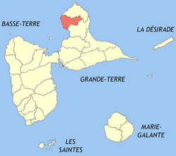 Location of the commune (in red) within Guadeloupe | |
| Coordinates: 16°25′00″N 61°32′00″W / 16.4167°N 61.5333°WCoordinates: 16°25′00″N 61°32′00″W / 16.4167°N 61.5333°W | |
| Country | France |
| Overseas region and department | Guadeloupe |
| Arrondissement | Pointe-à-Pitre |
| Canton | Petit-Canal |
| Government | |
| • Mayor | Jean Barfleur |
| Area1 | 44.24 km2 (17.08 sq mi) |
| Population (2013)2 | 5,825 |
| • Density | 130/km2 (340/sq mi) |
| INSEE/Postal code | 97122 /97117 |
|
1 French Land Register data, which excludes lakes, ponds, glaciers > 1 km2 (0.386 sq mi or 247 acres) and river estuaries. 2 Population without double counting: residents of multiple communes (e.g., students and military personnel) only counted once. | |
 Guadeloupe | |
| Location |
Port-Louis Guadeloupe France |
|---|---|
| Coordinates | 16°25′05.4″N 61°32′01.1″W / 16.418167°N 61.533639°W |
| Foundation | concrete base |
| Construction | concrete skeletal tower |
| Tower shape | square prism skeletal tower with closed lower part, balcony and light |
| Markings / pattern | yellow torwe with black horizontal band |
| Height | 10 metres (33 ft) |
| Focal height | 10 metres (33 ft) |
| Light source | mains power |
| Range | 11 nautical miles (20 km; 13 mi) |
| Characteristic | Q (9) W 15s. |
| Admiralty number | J5716 |
| NGA number | 14836[1][2] |
Port-Louis is a commune in the department of Guadeloupe, on the northwest of Grande-Terre.
Geography
Some settlements are depending of the commune of Port-Louis, such as:
.jpg)
History
The settlement of northern Grande-Terre began in the mid-17th century. The city was first known as Pointe d'Antigues then Port Louis (bearing the name of the king of France Louis XIV). At the beginning of the 18th century the city was one of the first sugar ports of Guadeloupe. Gradually Port-louis was dethroned by Le Moule and Pointe-à-Pitre. In the 19th century, the Domaine de Beauport was one of the most important sugar factories in the French West Indies. It closed definitively in 1990. Nevertheless, sugar cane and fishing remain the main economic activities of the commune.
Education
Public preschools and primary schools include:[3]
- Ecole primaire Robert Narayanan
- Ecole primaire Beauplan Pelletan
- Ecole maternelle Bourg 2 Port-Louis
- Ecole maternelle Virginie Naudillon
Public junior high schools include:[4]
- Collège Port-Louis
Public senior high schools include:[4]
- LPO Nord Grande-Terre
See also
References
- ↑ Port-Louis The Lighthouse Directory. University of North Carolina at Chapel Hill. Retrieved 30 August 2016
- ↑ List of Lights, Buoys and Fog Signals Atlantic Coast. Retrieved 30 August 2016
- ↑ "LISTE DES ECOLES PUBLIQUES ET PRIVEES SOUS CONTRAT." Académie de la Guadeloupe. Retrieved on 10 March 2018.
- 1 2 "Établissements du 2nd degré PUBLIC 2017-2018." Académie de la Guadeloupe. Retrieved on 10 March 2018.
| Wikimedia Commons has media related to Port-Louis (Guadeloupe). |