Baillif
| Baillif | |
|---|---|
| Commune | |
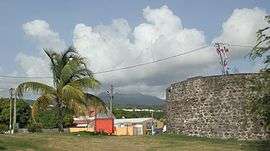 The tower of Father Labat, an historic monument | |
 Location of the commune (in red) within Guadeloupe | |
| Coordinates: 16°01′N 61°45′W / 16.02°N 61.75°WCoordinates: 16°01′N 61°45′W / 16.02°N 61.75°W | |
| Country | France |
| Overseas region and department | Guadeloupe |
| Arrondissement | Basse-Terre |
| Canton | Vieux-Habitants |
| Intercommunality | Sud Basse-Terre |
| Government | |
| • Mayor | Marie-Lucile Breslau |
| Area1 | 24.30 km2 (9.38 sq mi) |
| Population (2007)2 | 5,609 |
| • Density | 230/km2 (600/sq mi) |
| Demonym(s) | Baillifien |
| INSEE/Postal code | 97104 /97123 |
| Elevation |
0–1,354 m (0–4,442 ft) (avg. 15 m or 49 ft) |
|
1 French Land Register data, which excludes lakes, ponds, glaciers > 1 km2 (0.386 sq mi or 247 acres) and river estuaries. 2 Population without double counting: residents of multiple communes (e.g., students and military personnel) only counted once. | |
Baillif is a commune of Guadeloupe, an overseas region and department of France located in the Lesser Antilles. Baillif is a suburb of Basse-Terre, the prefecture and second largest urban area of Guadeloupe located on Basse-Terre Island (the western-half of Guadeloupe).
The inhabitants are called Baillifiens.
History
In 1637, Governor De L’Olive conceded a parcel of land to the Dominican monks, from the Fathers’ river to that of Baillif, and today these mark out the boundary of the town. Under the leadership of Father Labat, several fortresses were built in Baillif to protect the region from English invasion. The Dominicans came to preach the good news of Jesus.
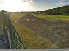
The commune is named after an early inhabitant, Robert Baillif. Baillif traded in the area from 1650 to about 1700. Today, Baillif is often considered to be a suburb of the prefecture of Guadeloupe, Basse-Terre, and with its small regional airfield, it acts as a gateway to the islands in the south. Marie-Lucile Breslau was elected (maire) mayor of Baillif.
Geography
Baillif is situated on the south-west coast of Basse-Terre Island and it covers an area of 24.3 km2 (9.4 sq mi). It faces the Caribbean Sea. The town is west of Basse-Terre's mountain range. The capital of Guadeloupe, Basse-Terre, is south of Baillif, and Vieux-Habitants, a village, is located north. La riviere de Père flows halfway between Baillif and Basse-Terre.
Climate
Like any other Eastern Caribbean settlement, Baillif experiences quite evenly spread rainfall during the year, with a wetter season between July and November which coincides with hurricane season. Guadeloupe has been struck by many hurricanes which have caused devastation. The town receives below 1500 mm of rainfall. Tropical heat is the norm, bringing constant highs of around 32 °C (89 °F) that drop to 20 °C (68 °F) at night.
Trade winds, called alizés, blow from the northeast and often temper the climate.
Economy
Baillif has mainly an agricultural sector a. Mixed crops such as bananas, cocoa and coffee are grown. They are shipped to the port or the airport to be transported. Baillif has an airport, Baillif Airport & the runway is 2,034 ft (620 m) and the International Civil Aviation Organization airport code is TFFB & the International Air Transport Association airport code is BBR.
Today, an industrial and commercial zone is under development, supplementing the Jarry zone.
Sights
With its small regional airfield, it acts as a gateway to the islands in the south.
At the entry to the market town, there is a 4 m tower as evidence of this historical past called the “Père Labat Tower”.
Further while going towards Vieux-Habitants, is the “engraved rocks” of Plessis.
Education
Public preschools and primary schools include:[1]
- Ecole primaire Saint-Robert
- Ecole primaire Bourg 1 Baillif
- Ecole maternelle Bourg Baillif
Public junior high schools include:[2]
- Collège Jean Jaures
Also to see
La Parc national de la Guadeloupe is a magnificent tropical forest of almost 66 square miles (170 km²), which has been a designated National Park since 1989. It has lots of well marked hiking trails of varying degrees of difficulty. Its lush vegetation (over 3000 species of trees) provides shelter for an exotic wildlife, free from poisonous animals. With its waterfalls, cascades, basins, parks and different plantations…it reveals all its natural charm! It is located in the mountain range from Belle Hotesse to La Soufriere.
Personalities
- Joseph Bologne, Chevalier de Saint-Georges, (1745–1799), French Composer, Violinist, Fencer, and Colonel of the Légion St.-Georges.
- Gratien Candace, (1873–1953), French politician
See also
References
- ↑ "LISTE DES ECOLES PUBLIQUES ET PRIVEES SOUS CONTRAT." Académie de la Guadeloupe. Retrieved on 10 March 2018.
- ↑ "Établissements du 2nd degré PUBLIC 2017-2018." Académie de la Guadeloupe. Retrieved on 10 March 2018.
| Wikimedia Commons has media related to Baillif. |