Saint-Claude, Guadeloupe
| Saint-Claude | |
|---|---|
| Commune | |
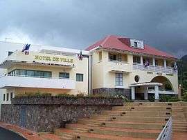 The new town hall of Saint-Claude | |
 | |
| Coordinates: 16°02′00″N 61°42′00″W / 16.0333°N 61.7°WCoordinates: 16°02′00″N 61°42′00″W / 16.0333°N 61.7°W | |
| Country | France |
| Overseas region and department | Guadeloupe |
| Arrondissement | Basse-Terre |
| Canton | Basse-Terre |
| Government | |
| • Mayor | Élie Califer |
| Area1 | 34.30 km2 (13.24 sq mi) |
| Population (2013)2 | 10,685 |
| • Density | 310/km2 (810/sq mi) |
| INSEE/Postal code | 97124 /97120 |
|
1 French Land Register data, which excludes lakes, ponds, glaciers > 1 km2 (0.386 sq mi or 247 acres) and river estuaries. 2 Population without double counting: residents of multiple communes (e.g., students and military personnel) only counted once. | |
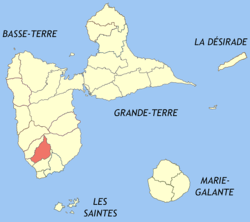
Saint-Claude is a French commune in the overseas department of Guadeloupe. It lies in the interior of southern Basse-Terre Island, just northeast of the capital city of Basse-Terre.
Education
Public preschools and primary schools include:[1]
- Ecole primaire Bourg 2 St-claude
- Ecole primaire Louis Chalcol
- Ecole primaire Félix Laban
- Ecole maternelle Nelson Rose
- Ecole maternelle Arlette Salomon
Public junior high schools include:[2]
- Collège Rémy Nainsouta
Public senior high schools include:[2]
- LDM du commerce, des services et de l'artisanat Ducharmoy
Private primary schools include:[1]
- Ecole primaire privée Saint Joseph de Cluny
See also
References
- 1 2 "LISTE DES ECOLES PUBLIQUES ET PRIVEES SOUS CONTRAT." Académie de la Guadeloupe. Retrieved on 10 March 2018.
- 1 2 "Établissements du 2nd degré PUBLIC 2017-2018." Académie de la Guadeloupe. Retrieved on 10 March 2018.
| Wikimedia Commons has media related to Saint-Claude (Guadeloupe). |
This article is issued from
Wikipedia.
The text is licensed under Creative Commons - Attribution - Sharealike.
Additional terms may apply for the media files.