Poivre Atoll
 Poivre Islands | |
| Geography | |
|---|---|
| Location | Indian Ocean |
| Coordinates | 05°46′S 53°19′E / 5.767°S 53.317°ECoordinates: 05°46′S 53°19′E / 5.767°S 53.317°E |
| Archipelago | Seychelles |
| Adjacent bodies of water | Indian Ocean |
| Total islands | 4 |
| Major islands |
|
| Area | 2.78 km2 (1.07 sq mi) |
| Coastline | 21 km (13 mi) |
| Highest elevation | 3 m (10 ft) |
| Administration | |
| Group | Outer Islands |
| Sub-Group | Amirante Islands |
| Districts | Outer Islands District |
| Largest settlement | Poivre Nord (pop. 8) |
| Demographics | |
| Population | 8 (2014) |
| Pop. density | 2.9 /km2 (7.5 /sq mi) |
| Ethnic groups | Creole, French, East Africans, Indians. |
| Additional information | |
| Time zone | |
| ISO code | SC-26 |
| Official website |
www |
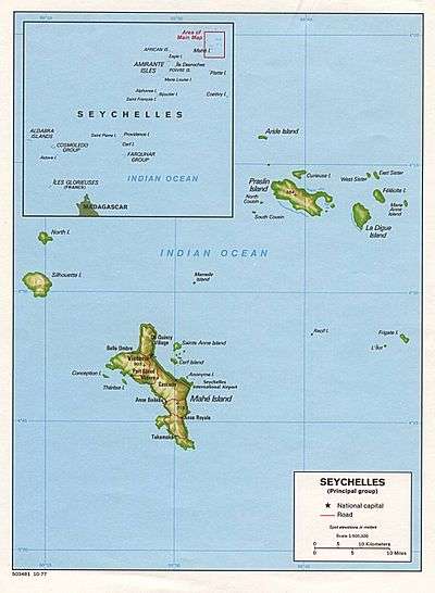
Poivre Islands are a group of islands in Seychelles, lying in the Outer Islands of Seychelles, with a distance of 268 km south of Victoria, Seychelles.
History
Poivre was named in 1771 by Chevalier de la Biollière after Pierre Poivre, the famous "Peter Pepper" and governor of Ile de France and Réunion (then Bourbon) from 1769 to 1772.[1][2] He named Florentin island for the Grey herons (Florentin being the Creole name for this species),[3] which are nesting on the island. In 2008, the small boat channel was enlarged.[4] In 2017, a 30-room hotel will be opened by the IDC [5][6] and by Collins group.[7] In 2017, Collins group will open some private residential villas on the island.
Geography
Poivre Atoll is near the eastern edge of Amirante Bank. Poivre Nord is joined to Poivre Sud by a 750-metre causeway crossing the reef flats, which is submerged at high tide. The total area of the reef is 20.24 km2 There are four islets on the reef (with land area):
- Poivre Nord, 1.105 km2, located at 05°44′48″S 53°18′20″E / 5.74667°S 53.30556°E
- Poivre Sud, 1.5 km2, located at 05°46′18″S 53°18′22″E / 5.77167°S 53.30611°E, and with two additional small projections:
- Florentin, 0.163 km2 located at 05°45′40″S 53°18′07″E / 5.76111°S 53.30194°E
- Mozambique, 0.01 km2 located at 05°45′48″S 53°18′30″E / 5.76333°S 53.30833°E
The large, elongated lagoon between the 4 islands is very shallow and dries out at low tide.[4]
Demographics
The village stands on the east point of Poivre Nord Island, amid a clump of trees.[8] In some sources it is referenced as Pointe Baleine village. The village houses a handful of caretakers and conservationists who watch over the precious ecosystem and maintain the unpaved grass aeroplane runway. The ruined buildings on Poivre Nord hint at a more grandiose past and are oddly juxtaposition-ed alongside the more modern habitable homes.[9]
Administration
The island belongs to Outer Islands District.[10] Being an island with a small population, there are not any government buildings or services. For many services, people have to go to Victoria, which is a difficult task.
Transport
Poivre Nord Island is bisected by a 1,100 metres (3,600 ft) unpaved airfield. The island is occasionally serviced by an Island Development Company (IDC) aircraft from Mahé.
Economics
The inhabitants on the island are engaged in very small scale farming and livestock which are mainly for the island consumption.[11]
Flora and fauna
The island is known for its rich fish life.
Tourism
There are several local contractors who offer Permit fishing trips to the island.
Image gallery
 Map 1
Map 1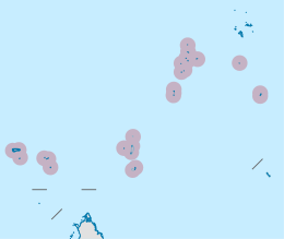 District Map
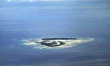 Poivre Atoll from the south
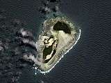 Sat image
References
- ↑ (in German) Panorama der lexikalischen Semantik: thematische Festschrift aus Anlass des 60. Geburtstags von Horst Geckeler, Gunter Narr Verlag, https://books.google.com/books?id=OoRnbumZU88C&pg=PA408
- ↑ History of the island
- ↑ Florentin name
- 1 2 Atoll research bulletin
- ↑ Official site
- ↑ Hotel site in construction
- ↑ Collins Poivre
- ↑ Resort staff quarters info
- ↑ Article on Poivre from 2016
- ↑ District map
- ↑ "Information on the island". Archived from the original on 2016-03-19. Retrieved 2016-04-06.
External links
| Wikimedia Commons has media related to Poivre Islands. |
- Island guide 1
- Island guide 2
- National Bureau of Statistics
- Info on the island
- 2010 Sailing directions
Outer islands of Seychelles / Coralline Seychelles (Zil Elwannyen Sesel) | |||||||||||
|---|---|---|---|---|---|---|---|---|---|---|---|
| Outer island Groups |  | ||||||||||
| Islands and Atolls |
| ||||||||||