Southern Coral Group
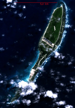 Coëtivy Island. NASA Image | |
 Southern Coral Group | |
| Geography | |
|---|---|
| Location | Indian Ocean |
| Coordinates | 06°30′S 55°44′E / 6.500°S 55.733°ECoordinates: 06°30′S 55°44′E / 6.500°S 55.733°E |
| Archipelago | Seychelles |
| Adjacent bodies of water | Indian Ocean |
| Total islands | 2 |
| Major islands |
|
| Area | 9.908 km2 (3.826 sq mi) |
| Highest elevation | 21 m (69 ft) |
| Highest point | Coëtivy |
| Administration | |
| Group | Outer Islands |
| Sub-Group | Southern Coral Group |
| Districts | Outer Islands District |
| Largest settlement | Coëtivy (pop. 260) |
| Demographics | |
| Population | 263 (2014) |
| Pop. density | 26.5 /km2 (68.6 /sq mi) |
| Ethnic groups | Creole, French, East Africans, Indians. |
| Additional information | |
| Time zone | |
| ISO code | SC-26 |
| Official website |
www |
Southern Coral Group is a collective term for two islands of Outer Islands of the Seychelles, lying in the south of the island nation, between 135 and 300 kilometers south of the capital, Victoria, on Mahé Island.
Islands
Two widely separated islands, with a distance of 171 km from one another, make up the Southern Coral Group. They are both sand cays, situated on the northeastern sides of pseudo-atolls:
- Île Platte in the north
- Coëtivy Island in the southeast
Population
Both islands are inhabited. The main settlement is on Coëtivy Island.
References
External links
Outer islands of Seychelles / Coralline Seychelles (Zil Elwannyen Sesel) | |||||||||||
|---|---|---|---|---|---|---|---|---|---|---|---|
| Outer island Groups |  | ||||||||||
| Islands and Atolls |
| ||||||||||
This article is issued from
Wikipedia.
The text is licensed under Creative Commons - Attribution - Sharealike.
Additional terms may apply for the media files.