Crutchfield Crossroads, North Carolina
| Crutchfield Crossroads, North Carolina | |
|---|---|
| Unincorporated community | |
 Location of Crutchfield Crossroads in North Carolina  Crutchfield Crossroads, North Carolina (the US) | |
| Coordinates: 35°48′31″N 79°25′57″W / 35.80861°N 79.43250°W | |
| Country | United States |
| State | North Carolina |
| County | Chatham |
| Elevation[1] | 627 ft (191 m) |
| Time zone | UTC-5 (Eastern (EST)) |
| • Summer (DST) | UTC-4 (EST) |
| GNIS feature ID | 985012[1] |
Crutchfield Crossroads is an unincorporated community in northwestern Chatham County, North Carolina north of the town of Siler City. Crutchfield Crossroads is commonly defined as the area in and around the rural intersection of Silk Hope-Liberty Road. and Siler City- Snow Camp Road. At the intersection of the two roads, there are some stores, but other than that the entire community is agricultural. Children living in this area attend schools in Silk Hope and Siler City.
Some of North Carolina's oldest farms are located near this intersection. The Whitehead-Fogleman Farm was listed on the National Register of Historic Places in 1985.[2]
References
- 1 2 U.S. Geological Survey Geographic Names Information System: Crutchfield Crossroads, North Carolina. Retrieved on 22 October 2008.
- ↑ National Park Service (2010-07-09). "National Register Information System". National Register of Historic Places. National Park Service.
Municipalities and communities of Chatham County, North Carolina, United States | ||
|---|---|---|
| Towns | 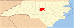 | |
| CDPs | ||
| Unincorporated communities | ||
| Footnotes | ‡This populated place also has portions in an adjacent county or counties | |
Coordinates: 35°48′31″N 79°25′57″W / 35.80861°N 79.43250°W
This article is issued from
Wikipedia.
The text is licensed under Creative Commons - Attribution - Sharealike.
Additional terms may apply for the media files.