Pisang
| Pisang पिसाङ | |
|---|---|
| Village development committee | |
 Pisang | |
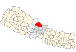
 Pisang Location in Nepal | |
| Coordinates: 28°37′00″N 84°09′00″E / 28.61673°N 84.14991°ECoordinates: 28°37′00″N 84°09′00″E / 28.61673°N 84.14991°E | |
| Country |
|
| Zone | Gandaki |
| District | Manang |
| Elevation | 3,250 m (10,660 ft) |
| Population (2011)[1] | |
| • Total | 307 |
| Time zone | UTC+5:45 (Nepal Time) |
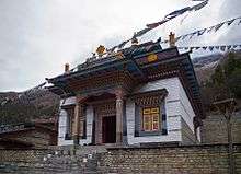
Buddhist temple in Pisang
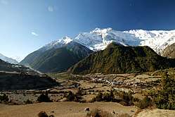
Pisang is a village development committee in Manang District in the Gandaki Zone of northern Nepal. At the time of the 2011 Nepal census it had a population of 307 people living in 105 individual households. The village is located in the Marshyangdi River valley, directly south of Pisang Peak, north of Annapurna II, and west of Paungda Danda.
References
- ↑ "National Population and Housing Census 2011(Village Development Committee/Municipality)" (PDF). Government of Nepal. National Planning Commission. November 2012.
Headquarters: Chame Rural Municipality | ||
| Rural municipalities |
|  |
| Former VDCs | ||
This article is issued from
Wikipedia.
The text is licensed under Creative Commons - Attribution - Sharealike.
Additional terms may apply for the media files.