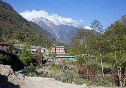
Bagarchhap
| Bagarchhap बगरछाप | |
|---|---|
| Village development committee | |
 Bagarchhap | |
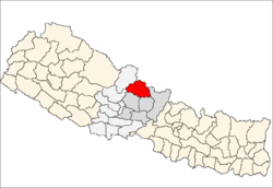
 Bagarchhap Location in Nepal | |
| Coordinates: 28°32′N 84°20.3′E / 28.533°N 84.3383°ECoordinates: 28°32′N 84°20.3′E / 28.533°N 84.3383°E | |
| Country |
|
| Zone | Gandaki Zone |
| District | Manang District |
| Population (1991) | |
| • Total | 534 |
| Time zone | UTC+5:45 (Nepal Time) |
Bagarchhap is a village development committee in Manang District in the Gandaki Zone of northern Nepal. At the time of the 1991 Nepal census it had a population of 534 people living in 116 individual households.[1]
On 10 November 1995 most of Bagarchap (around 80%) was destroyed by a landslide, which killed 11 villagers and 9 trekkers. Many villagers relocated to Danaque to the west and Bagarchhap is now much smaller than it was prior to the landslide.[2]
References
- ↑ "Nepal Census 2001", Nepal's Village Development Committees, Digital Himalaya, archived from the original on 12 October 2008, retrieved 15 November 2009 .
- ↑ "Annapurna Circuit - Day 4 (Chamje - Bagarchap)". travbuddy.com.
Headquarters: Chame Rural Municipality | ||
| Rural municipalities |
|  |
| Former VDCs | ||
This article is issued from
Wikipedia.
The text is licensed under Creative Commons - Attribution - Sharealike.
Additional terms may apply for the media files.