Pinneberg (district)

Pinneberg
District

Flag

Coat of arms
Country  Germany
State Schleswig-Holstein
Capital Pinneberg
Area
  Total 664 km2 (256 sq mi)
Population (31 December 2016)[1]
  Total 310,653
  Density 470/km2 (1,200/sq mi)
Time zone UTC+01:00 (CET)
  Summer (DST) UTC+02:00 (CEST)
Vehicle registration PI
Website kreis-pinneberg.de

Pinneberg is a district in Schleswig-Holstein, Germany. It is bounded by (from the northwest and clockwise) the districts of Steinburg and Segeberg, the city (and state) of Hamburg and the state of Lower Saxony (district Stade). The island of Heligoland is also part of the district.

History

The district is roughly identical to the former county of Holstein-Pinneberg. It was established by the Prussian administration in 1867. Since then there has been a continuous loss of territory to the neighbouring cities of Altona (later itself a part of Hamburg), Hamburg and Norderstedt. The island of Heligoland, formerly a district by itself, joined the district in 1932.

Geography

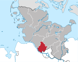
The district is situated on the northern bank of the Elbe River. While Pinneberg is the smallest district within Schleswig-Holstein, it has the most inhabitants. Due to the growing Hamburg metropolitan area the population is still increasing. The district consists mainly of the northwestern suburbs of Hamburg. Although the district of Pinneberg is only connected to the sea through the Elbe, the archipelago of Heligoland became a part of this district in 1932.

Coat of arms

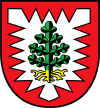
The coat of arms displays a fir tree inside a white nettle-leaf. The leaf is from the arms of the county of Holstein-Schauenburg. The tree symbolises the forestry in the district.

Towns and municipalities

Independent townsIndependent municipalities
  1. Barmstedt
  2. Elmshorn
  3. Pinneberg
  4. Quickborn
  5. Schenefeld
  6. Tornesch
  7. Uetersen
  8. Wedel
  1. Bönningstedt
  2. Halstenbek
  3. Hasloh
  4. Heligoland
  5. Rellingen
Ämter
  1. Klein Nordende
  2. Klein Offenseth-Sparrieshoop
  3. Kölln-Reisiek
  4. Raa-Besenbek
  5. Seester
  6. Seestermühe
  7. Seeth-Ekholt
  1. Appen
  2. Groß Nordende
  3. Haselau
  4. Haseldorf
  5. Heidgraben
  6. Heist
  7. Hetlingen
  8. Holm
  9. Moorrege1
  10. Neuendeich
  1. Bokel
  2. Brande-Hörnerkirchen1
  3. Osterhorn
  4. Westerhorn
  1. Borstel-Hohenraden
  2. Ellerbek
  3. Kummerfeld
  4. Prisdorf
  5. Tangstedt
  1. Bevern
  2. Bilsen
  3. Bokholt-Hanredder
  4. Bullenkuhlen
  5. Ellerhoop
  6. Groß Offenseth-Aspern
  7. Heede
  8. Hemdingen
  9. Langeln
  10. Lutzhorn
1seat of the Amt

References

  1. "Statistikamt Nord – Bevölkerung der Gemeinden in Schleswig-Holstein 4. Quartal 2016] (XLS-file)". Statistisches Amt für Hamburg und Schleswig-Holstein (in German).

Media related to Kreis Pinneberg at Wikimedia Commons

Coordinates: 53°45′N 9°45′E / 53.75°N 9.75°E / 53.75; 9.75

This article is issued from Wikipedia. The text is licensed under Creative Commons - Attribution - Sharealike. Additional terms may apply for the media files.