Pinetown Bushong's Mill Covered Bridge
| Pinetown Bushong's Mill Covered Bridge | |
|---|---|
 | |
| Coordinates | 40°06′19″N 76°14′54″W / 40.1053°N 76.2482°WCoordinates: 40°06′19″N 76°14′54″W / 40.1053°N 76.2482°W |
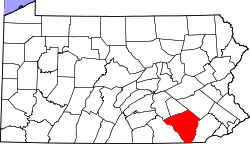
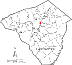
| Locale | Lancaster County, Pennsylvania, United States |
| Official name | Big Conestoga #6 Bridge |
| Characteristics | |
| Design | single span, double Burr arch truss |
| Total length | 133 feet (41 m) |
| History | |
| Constructed by | Elias McMellen |
| Construction start | 1867 |
 | |
 | |
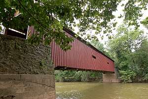
The Pinetown Bushong's Mill Covered Bridge is a covered bridge that spans the Conestoga River in Lancaster County, Pennsylvania, United States. A county-owned and maintained bridge, its official designation is the Big Conestoga #6 Bridge.[1] The bridge is also known as Pinetown Covered Bridge, Nolte's Point Mill Bridge and Bushong's Mill Bridge.
The bridge has a single span, wooden, double Burr arch trusses design with the addition of steel hanger rods. The deck is made from oak planks.[1] It is painted red, the traditional color of Lancaster County covered bridges, on both the inside and outside. Both approaches to the bridge are painted in red with white trim.
The bridge's WGCB Number is 38-36-05. Added in 1980, it is listed on the National Register of Historic Places as structure number 80003527.[2] It is located at 40°6′19.2″N 76°14′53.4″W / 40.105333°N 76.248167°W (40.10533, -76.24817).[3]
History
The bridge was built in 1867 by Elias McMellen at a cost of $4,500. In 1972 it was destroyed as a result of flooding caused by Hurricane Agnes. Due to a tremendous response of area residents who signed a petition for its reconstruction, it was among the first covered bridges to be restored after Agnes. In the spring of 1973 the bridge was rebuilt by the nearby Amish. To prevent damage due to future flooding, they raised the bridge to 17 feet 6 inches (5.33 m) above the average water line.[4] However, the bridge was closed after flood damage sustained due to Tropical Storm Lee in 2011.[5] The bridge was reopened in January 2014.[6]
Dimensions
- Length: 124 feet (38 m) span and 133 feet (41 m) total length
- Width: 12 feet 10 inches (3.91 m) clear deck and 15 feet (4.6 m) total width[7]
- Overhead clearance: 11 feet 6 inches (3.51 m)
- Underclearance: 15 feet (4.6 m) as listed by the county government[1] or 17 feet 6 inches (5.33 m) with respect to the average water level[4]
Gallery
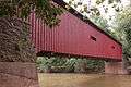 A view of the bridge from the side
 One of the approaches to the bridge
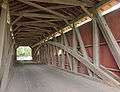 The inside of the bridge showing the Burr arch truss
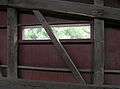 A view from inside of the window on the side of the bridge
See also
References
- 1 2 3 4 "Pinetown Bushong's Mill Covered Bridge". Lancaster County, PA Government Portal. County of Lancaster, Pennsylvania. 2001-10-30. Retrieved 2006-07-07.
- ↑ "PENNSYLVANIA - Lancaster County". National Register of Historic Places. Retrieved 2007-03-20.
- ↑ Travis, Dale. "38-36-05". Round Barns & Covered Bridges. Retrieved 2006-08-08.
- 1 2 "Pinetown Covered Bridge". Lancaster County Pennsylvania Dutch Country Official Visitors Center. Pennsylvania Dutch Convention & Visitors Bureau. 2006. Retrieved 2006-07-07.
- ↑ "Commissioners Order Damage Assessment for all County-Owned Bridges". Lancaster County, Pennsylvania. Retrieved 2011-09-11.
- ↑ "Pinetown covered bridge to reopen this week". LancasterOnline.
- ↑ McCain, Dr. Roger A. "Pinetown Bridge". A Guide to Old Covered Bridges of Southeastern Pennsylvania and nearby areas. Retrieved 2006-08-04.
| Topics |   | |
|---|---|---|
| Lists by county |
| |
| Lists by city | ||
| Other lists | ||
| ||