El Pinell de Brai
| El Pinell de Brai | |||
|---|---|---|---|
| Municipality | |||
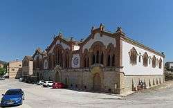 Cooperative building, El Pinell de Brai | |||
| |||
 El Pinell de Brai Location in Catalonia | |||
| Coordinates: 41°01′02″N 0°30′56″E / 41.01722°N 0.51556°ECoordinates: 41°01′02″N 0°30′56″E / 41.01722°N 0.51556°E | |||
| Country |
| ||
| Community |
| ||
| Province | Tarragona | ||
| Comarca | Terra Alta | ||
| Government | |||
| • mayor | Marc Martínez Aroca (2015)[1] | ||
| Area[2] | |||
| • Total | 57.0 km2 (22.0 sq mi) | ||
| Elevation | 101 m (331 ft) | ||
| Population (2014)[1] | |||
| • Total | 1,076 | ||
| • Density | 19/km2 (49/sq mi) | ||
| Climate | Csa | ||
| Website |
www | ||


El Pinell de Brai is a municipality in the comarca of la Terra Alta in Catalonia, Spain.
This town is located in a small plain surrounded by mountains including Serra de Pàndols and Serra de Cavalls. This area suffered badly during the Battle of the Ebro in the Spanish Civil War (1936–39). There is a point called Hill 705 Cota 705 on top of the highest peak of Serra de Pàndols range near the town on which stands a monument to those who died in the battles.[3] Like in Corbera d'Ebre, some of the town's houses destroyed in the Civil War have been kept as they are and are known as "The Fallen Houses" Les Cases Caigudes.
References
- 1 2 "Ajuntament del Pinell de Brai". Generalitat of Catalonia. Retrieved 2015-11-13.
- ↑ "El municipi en xifres: El Pinell de Brai". Statistical Institute of Catalonia. Retrieved 2015-11-23.
- ↑ The Battle of the Ebro in one day Archived 2011-07-19 at the Wayback Machine.
External links
| Wikimedia Commons has media related to El Pinell de Brai. |
- Pàgina web de l'Ajuntament
- Government data pages (in Catalan)
Places adjacent to El Pinell de Brai | ||||||||||
|---|---|---|---|---|---|---|---|---|---|---|
| ||||||||||
Municipalities of Terra Alta | ||
|---|---|---|
This article is issued from
Wikipedia.
The text is licensed under Creative Commons - Attribution - Sharealike.
Additional terms may apply for the media files.