Pila, Piedmont
| Pila | |
|---|---|
| Comune | |
| Comune di Pila | |
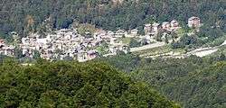 Pila from a nearby hillside | |
 Pila Location of Pila in Italy | |
| Coordinates: 45°46′N 8°5′E / 45.767°N 8.083°ECoordinates: 45°46′N 8°5′E / 45.767°N 8.083°E | |
| Country | Italy |
| Region | Piedmont |
| Province | Province of Vercelli (VC) |
| Government | |
| • Mayor | Enrico Cottura |
| Area | |
| • Total | 8.7 km2 (3.4 sq mi) |
| Population (Dec. 2004) | |
| • Total | 118 |
| • Density | 14/km2 (35/sq mi) |
| Time zone | UTC+1 (CET) |
| • Summer (DST) | UTC+2 (CEST) |
| Postal code | 13020 |
| Dialing code | 0163 |
Pila is a comune (municipality) in the Province of Vercelli in the Italian region Piedmont, located about 80 kilometres (50 mi) northeast of Turin and about 60 kilometres (37 mi) northwest of Vercelli. As of 31 December 2004, it had a population of 118 and an area of 8.7 square kilometres (3.4 sq mi).[1]
Pila borders the following municipalities: Pettinengo, Piode, and Scopello.
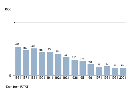
Demographic evolution
References

This article is issued from
Wikipedia.
The text is licensed under Creative Commons - Attribution - Sharealike.
Additional terms may apply for the media files.