Roasio
| Roasio | |
|---|---|
| Comune | |
| Comune di Roasio | |
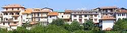 | |
 Roasio Location of Roasio in Italy | |
| Coordinates: 45°37′N 8°17′E / 45.617°N 8.283°ECoordinates: 45°37′N 8°17′E / 45.617°N 8.283°E | |
| Country | Italy |
| Region | Piedmont |
| Province | Province of Vercelli (VC) |
| Frazioni | San Maurizio, Castelletto Villa, San Giorgio, Sant' Eusebio, Corticella, Curavecchia, Prucengo |
| Area | |
| • Total | 28.1 km2 (10.8 sq mi) |
| Elevation | 278 m (912 ft) |
| Population (Dec. 2004) | |
| • Total | 2,517 |
| • Density | 90/km2 (230/sq mi) |
| Demonym(s) | Roasiani |
| Time zone | UTC+1 (CET) |
| • Summer (DST) | UTC+2 (CEST) |
| Postal code | 13060 |
| Dialing code | 0163 |
| Website | Official website |
Roasio is a comune (municipality) in the Province of Vercelli in the Italian region Piedmont, located about 80 kilometres (50 mi) northeast of Turin and about 35 kilometres (22 mi) northwest of Vercelli. As of 31 December 2004, it had a population of 2,517 and an area of 28.1 square kilometres (10.8 sq mi).[1]
The municipality of Roasio contains the frazioni (subdivisions, mainly villages and hamlets) San Maurizio, Castelletto Villa, San Giorgio, Sant' Eusebio, Corticella, Curavecchia, and Prucengo.
Roasio borders the following municipalities: Brusnengo, Curino, Gattinara, Lozzolo, Rovasenda, Sostegno, and Villa del Bosco.
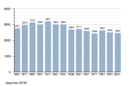
Demographic evolution
References
External links

This article is issued from
Wikipedia.
The text is licensed under Creative Commons - Attribution - Sharealike.
Additional terms may apply for the media files.