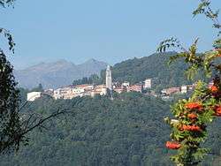
Pettinengo
| Pettinengo | |
|---|---|
| Comune | |
| Comune di Pettinengo | |
 | |
 Pettinengo Location of Pettinengo in Italy | |
| Coordinates: 45°33′N 8°6′E / 45.550°N 8.100°ECoordinates: 45°33′N 8°6′E / 45.550°N 8.100°E | |
| Country | Italy |
| Region | Piedmont |
| Province | Province of Biella (BI) |
| Frazioni | Azario, Fassoletto, Gurgo, Livera, Mazza, Miniggio, Molinetto, Perino, Piana, San Francesco, Selva, Trivero, Vaglio, Selve Marcone, Rosa, Burzano, Rossi |
| Area | |
| • Total | 11.5 km2 (4.4 sq mi) |
| Population (Dec. 2004) | |
| • Total | 1,567 |
| • Density | 140/km2 (350/sq mi) |
| Time zone | UTC+1 (CET) |
| • Summer (DST) | UTC+2 (CEST) |
| Postal code | 13050 |
| Dialing code | 015 |
Pettinengo is a comune (municipality) in the Province of Biella in the Italian region Piedmont, located about 60 kilometres (37 mi) northeast of Turin and about 3 kilometres (2 mi) southeast of Biella. As of 31 December 2004, it had a population of 1,567 and an area of 11.5 square kilometres (4.4 sq mi).[1]
Pettinengo borders the following municipalities: Andorno Micca, Biella, Bioglio, Callabiana, Camandona, Piedicavallo, Pila, Piode, Rassa, Ronco Biellese, Scopello, Tavigliano, Ternengo, Valle Mosso, Valle San Nicolao, Veglio, Zumaglia.
History
From 1 January 2017 Pettinengo absorbed the neighbouring municipality of Selve Marcone.[2]
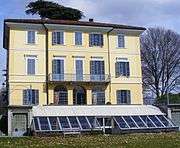
Villa Piazzo
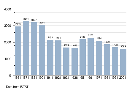
Demographic evolution
References
![]()
- ↑ All demographics and other statistics: Italian statistical institute Istat.
- ↑ Regione Piemonte. "Bollettino Ufficiale" (PDF). Legge regionale 12 dicembre 2016, n. 26. (2016-15–12). Regione Piemonte. Retrieved 2017-04-24.


This article is issued from
Wikipedia.
The text is licensed under Creative Commons - Attribution - Sharealike.
Additional terms may apply for the media files.