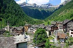
Carcoforo
| Carcoforo | |
|---|---|
| Comune | |
| Comune di Carcoforo | |
 | |
 Carcoforo Location of Carcoforo in Italy | |
| Coordinates: 45°54′N 8°3′E / 45.900°N 8.050°ECoordinates: 45°54′N 8°3′E / 45.900°N 8.050°E | |
| Country | Italy |
| Region | Piedmont |
| Province | Vercelli (VC) |
| Government | |
| • Mayor | Marino Sesone |
| Area | |
| • Total | 22.8 km2 (8.8 sq mi) |
| Elevation | 1,304 m (4,278 ft) |
| Population (31 May 2017)[1] | |
| • Total | 73 |
| • Density | 3.2/km2 (8.3/sq mi) |
| Demonym(s) | Carcoforesi |
| Time zone | UTC+1 (CET) |
| • Summer (DST) | UTC+2 (CEST) |
| Postal code | 13026 |
| Dialing code | 0163 |
| Website | Official website |
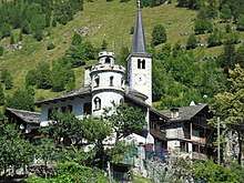
Campanile and the tower house
Carcoforo is a comune (municipality) in the province of Vercelli in the Italian region Piedmont, located about 100 kilometres (62 mi) northeast of Turin and about 70 kilometres (43 mi) northwest of Vercelli.
Carcoforo borders the following municipalities: Alto Sermenza, Bannio Anzino, Ceppo Morelli, Fobello and Macugnaga.
References

This article is issued from
Wikipedia.
The text is licensed under Creative Commons - Attribution - Sharealike.
Additional terms may apply for the media files.