Pieman River
| Pieman | |
| River | |
 The Pieman River | |
| Name origin: Thomas Kent[1] | |
| Country | Australia |
|---|---|
| State | Tasmania |
| Region | West Coast |
| Tributaries | |
| - left | Ring River, Stitt River, Heemskirk River |
| - right | Marionoak River, Wilson River (Tasmania), Huskisson River, Stanley River (Tasmania), Paradise River (Tasmania), Owen Meredith River, Savage River (Tasmania), Whyte River, Donaldson River (Tasmania) |
| Source confluence | Mackintosh River and Murchison River |
| - location | below Tullah |
| - elevation | 191 m (627 ft) |
| Mouth | Hardwicke Bay |
| - elevation | 0 m (0 ft) |
| - coordinates | 41°40′13″S 144°55′9″E / 41.67028°S 144.91917°ECoordinates: 41°40′13″S 144°55′9″E / 41.67028°S 144.91917°E |
| Length | 26 km (16 mi) |
| Reservoir | Lake Rosebury, Lake Pieman |
| Dams | Reece Dam, Bastyan Dam |
| Nature reserves | Pieman River SR, Tikkawoppa Plateau RR, Bernafai Ridge CA |
| [2] | |

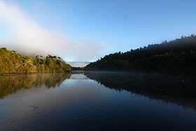
The Pieman River is a major perennial river located in the west coast region of Tasmania, Australia.
Course and features
Formed by the confluence of the Mackintosh River and Murchison River, the Pieman River rises in what is now known as Lake Rosebury, an artificial lake formed by the Bastyan Dam. The river flows generally west and northwest and then west again, joined by 21 tributaries including the Mackintosh, Murchison, Marionoak, Ring, Wilson, Stitt, Huskisson, Stanley, Heemskirk, Paradise, Owen Meredith, Savage, Whyte and Donaldson rivers before emptying into Hardwicke Bay and reaching its mouth in the Southern Ocean. The river descends 191 metres (627 ft) over its 100-kilometre (62 mi) course.[2]
The river is impounded at Bastyan by the Bastyan Dam (and adjacent hydroelectric power station to form Lake Rosebury; and at Reece by the Reece Dam (and adjacent hydroelectric power station to form Lake Pieman. Both reservoir and power stations from part of the Hydro Tasmania-operated Pieman River Power Development. The construction of the power development scheme also altered the route of the Emu Bay Railway, and submerged a variety of rail heritage sites in the vicinity of the river, notably parts of the Wee Georgie Wood Railway or North Farrell Tramway line.[3][4][5]
Etymology
The once-common suggestion that it was named after a convict "The Pieman" Alexander Pearce who was responsible for one of the few recorded instances of cannibalism in Australia, is not correct. "The Pieman" was in fact Thomas Kent of Southampton, a pastry-cook who was transported to Van Diemen's Land in 1816. After a long series of offences in the colony, he was sent to the Macquarie Harbour Penal Station in 1822 but subsequently escaped, and was recaptured near the mouth of the river which now bears his nickname.[1] The river has significant timber, mining and industrial heritage along its shores.
See also
References
- 1 2 Sprod, Dan (1977). Alexander Pearce of Macquarie Harbour. Cat & Fiddle Press. pp. 106–18. ISBN 0-85853-031-7.
- 1 2 "Map of Pieman River, TAS". Bonzle Digital Atlas of Australia. 2015. Retrieved 30 June 2015.
- ↑ Rae, Lou (1997). The Emu Bay Railway. ISBN 0-9592098-6-7.
- ↑ Atkinson, H.K. (1991). Railway Tickets of Tasmania. ISBN 0-9598718-7-X.
- ↑ Along the Line in Tasmania. Book 2. Private Lines. Traction Publications. 1972. ISBN 0-85829-003-0.
Maps
- "Pieman River power development map. Tourist map on orthophoto base, showing power developments, for the area Corinna-Lake Mackintosh-Trial Harbour. Includes power stations, tourist facilities, and historical notes" (Map) (cartographic material, reproduction)
|format=requires|url=(help). Survey Section. 1:60 000. Tasmania: Hydro-Electric Commission. 1982. § E 145°05'--E 145°46'/S 41°37'--S 42°00'.
External links
- "The Pieman Catchment". Hydro Tasmania. Archived from the original on 2004-12-04.
River systems and rivers of Tasmania, Australia | |||||
|---|---|---|---|---|---|
| |||||
| |||||
| |||||
|