Darwin Dam
| Darwin Dam | |
|---|---|
 Location of the Darwin Dam in Tasmania | |
| Country | Australia |
| Location | West Coast Tasmania |
| Coordinates | 42°12′36″S 145°36′36″E / 42.21000°S 145.61000°ECoordinates: 42°12′36″S 145°36′36″E / 42.21000°S 145.61000°E |
| Purpose | Power |
| Status | Operational |
| Opening date | 1990 |
| Owner(s) | Hydro Tasmania |
| Dam and spillways | |
| Type of dam | Embankment dam |
| Impounds | off stream |
| Height | 20 metres (66 ft) |
| Length | 700 metres (2,300 ft) |
| Dam volume | 430×103 m3 (15×106 cu ft) |
| Spillways | 0 |
| Reservoir | |
| Creates | Lake Burbury |
| Total capacity | 1,081,420 ML (38,190×106 cu ft) |
| Active capacity | 1,065,000 ML (37,600×106 cu ft) |
| Catchment area | 559 km2 (216 sq mi) |
| Surface area | 53,250×103 m2 (573.2×10⁶ sq ft) |
|
Website hydro | |
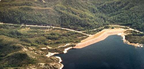
The Darwin Dam is an offstream earthfill embankment saddle dam without a spillway, located in Western Tasmania, Australia. The impounded reservoir, also formed by Crotty Dam, is called Lake Burbury.[1]
The dam was constructed in 1990 by the Hydro Electric Corporation (TAS) for the purpose of generating hydro-electric power via the John Butters Power Station.[2] It had been known during construction as the Andrew Divide Dam.[3]
Features and location
The Darwin Dam, together with the Crotty Dam, are two major dams that form the headwaters for the King River Hydroelectric Power Development. The dam is located at the southern end of Lake Burbury, and holds the water for the lake.
The Darwin Dam wall, constructed with 430 thousand cubic metres (15×106 cu ft) of earth core, is 20 metres (66 ft) high and 700 metres (2,300 ft) long. At 100% capacity the dam wall holds back 1,081,420 megalitres (38,190×106 cu ft) of water. The surface area of Lake Burbury is 53,250 hectares (131,600 acres) and the catchment area is 559 square kilometres (216 sq mi). The dam wall does not have a spillway.[4]
The dam draws its name from Mount Darwin, a peak located to the west of the dam wall. Both locations draw their names from the railway stopping place and the ghost town site of Darwin that was situated on the North Mount Lyell Railway between Gormanston and Kelly Basin. It inundates the former Kelly Basin Road which was the subsequent name for the railway line formation.
In the 1910s the Mount Lyell Mining and Railway Company had investigated and surveyed a site very close to this dam for a proposed scheme.
See also
References
- ↑ "Anthony and King Power Developments approved". Cross currents. Hydro-Electric Commission (70). 1969. ISSN 0811-4803.
- ↑ "King - Yolande". Energy: Our power stations. Hydro Tasminia. Retrieved 21 June 2015.
- ↑ HEC (1983) King River Power Development, HEC Public Relations, December 1983.
- ↑ "Register of Large Dams in Australia" (Excel (requires download)). Dams information. Australian National Committee on Large Dams. 2012. Retrieved 28 June 2015.
Further reading
- Blainey, Geoffrey (2000). The Peaks of Lyell (6th ed.). Hobart: St. David's Park Publishing. ISBN 0-7246-2265-9.
- Whitham, Charles (2003). Western Tasmania - A land of riches and beauty (Reprint 2003 ed.). Queenstown: Municipality of Queenstown.