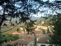
San Benedetto Val di Sambro
| San Benedetto Val di Sambro | |
|---|---|
| Comune | |
| Comune di San Benedetto Val di Sambro | |
 | |
 San Benedetto Val di Sambro Location of San Benedetto Val di Sambro in Italy | |
| Coordinates: 44°13′N 11°14′E / 44.217°N 11.233°ECoordinates: 44°13′N 11°14′E / 44.217°N 11.233°E | |
| Country | Italy |
| Region | Emilia-Romagna |
| Metropolitan city | Bologna (BO) |
| Frazioni | Castel dell'Alpi, Cedrecchia, La Villa di Cedrecchia, Madonna dei Fornelli, Monteacuto Vallese, Montefredente, Pian del Voglio, Pian di Balestra, Qualto, Ripoli, Sant'Andrea, Zaccanesca |
| Government | |
| • Mayor | Alessandro Santoni |
| Area | |
| • Total | 66.47 km2 (25.66 sq mi) |
| Elevation | 602 m (1,975 ft) |
| Population (31 December 2014)[1] | |
| • Total | 4,348 |
| • Density | 65/km2 (170/sq mi) |
| Demonym(s) | Sanbenedettesi |
| Time zone | UTC+1 (CET) |
| • Summer (DST) | UTC+2 (CEST) |
| Postal code | 40048 |
| Dialing code | 0534 |
| Website | Official website |
San Benedetto Val di Sambro (Medial Mountain Bolognese: San Bandàtt) is a comune (municipality) in the Metropolitan City of Bologna in the Italian region Emilia-Romagna, located about 35 kilometres (22 mi) southwest of Bologna.
See also
References
External links
![]()

This article is issued from
Wikipedia.
The text is licensed under Creative Commons - Attribution - Sharealike.
Additional terms may apply for the media files.