Bentivoglio, Emilia-Romagna
| Bentivoglio | |
|---|---|
| Comune | |
| Comune di Bentivoglio | |
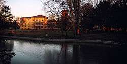 Villa Smeraldi. | |
 Bentivoglio Location of Bentivoglio in Italy | |
| Coordinates: 44°38′N 11°25′E / 44.633°N 11.417°ECoordinates: 44°38′N 11°25′E / 44.633°N 11.417°E | |
| Country | Italy |
| Region | Emilia-Romagna |
| Metropolitan city | Bologna (BO) |
| Government | |
| • Mayor | Erika Ferranti |
| Area | |
| • Total | 51.1 km2 (19.7 sq mi) |
| Elevation | 19 m (62 ft) |
| Population (30 April 2017)[1] | |
| • Total | 5,495 |
| • Density | 110/km2 (280/sq mi) |
| Demonym(s) | Bentivogliesi |
| Time zone | UTC+1 (CET) |
| • Summer (DST) | UTC+2 (CEST) |
| Postal code | 40010 |
| Dialing code | 051 |
| Website | Official website |
Bentivoglio (Northern Bolognese: Bäntvói or Bentvói) is a comune (municipality) in the Metropolitan City of Bologna in the Italian region of Emilia-Romagna, located about 15 kilometres (9 mi) northeast of Bologna.
Bentivoglio borders the following municipalities: Argelato, Castel Maggiore, Granarolo dell'Emilia, Malalbergo, Minerbio, San Giorgio di Piano, San Pietro in Casale.
History
First settlements in Bentivoglio's territory date back to the Villanovan civilization, as testified by some cremation tombs dating from the 10th century BC and by a 6th century BC stele. The Romans carried first measures for land reclamation.
In the Middle Ages the central area of the territory was called "Poledrano Bridge"; the name stemmed from the passage of foals on the Navile canal bridge.
Main sights
- Museo della civiltà contadina at Villa Smeraldi.
