Petitcodiac, New Brunswick
| Petitcodiac | ||
|---|---|---|
| Village | ||
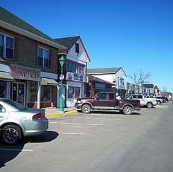 Downtown Petitcodiac | ||
| ||
| Nickname(s): "Where the River Begins" | ||
 Petitcodiac The location of Petitcodiac within New Brunswick | ||
| Coordinates: 45°55′55″N 65°10′11″W / 45.93205°N 65.169697°W | ||
| Country | Canada | |
| Province | New Brunswick | |
| County | Westmorland County | |
| Incorporated Village | November 9, 1966 | |
| Electoral Districts Federal |
Fundy Royal | |
| Provincial | Petitcodiac | |
| Government | ||
| • Mayor | Gerald Gogan | |
| Area | ||
| • Land | 17.22 km2 (6.65 sq mi) | |
| Population (2016) | ||
| • Total | 1,383 | |
| • Density | 83.0/km2 (215/sq mi) | |
| Time zone | UTC-4 (Atlantic (AST)) | |
| • Summer (DST) | UTC-3 (ADT) | |
| Website | Petitcodiac.ca | |

Petitcodiac is a Canadian village in Westmorland County, New Brunswick.
History
It is named after the Petitcodiac River, which begins in the village at the junction of the North River and Anagance River. The name is believed to be derived either from a Mi'kmaq word meaning "bends like a bow" or from a Maliseet word meaning "sound of thunder".[1]
Present day

The Community Centres around Route 890, Route 885, Route 905, Route 106 and Route 1.
The village features a regional school, an outdoor swimming pool, an arena, a bowling alley, as well as several family-owned shops and churches servicing the surrounding area. There is also a Royal Canadian Air Cadet Squadron.
The Westmorland County Agricultural Fair, established by William Balzer in 1967, is an agricultural fair with a horse show, a sheep show, a produce contest, crafts and baked goods, and a beauty pageant.[2]
Demography
|
Population trend [3]
|
Religious make-up (2001)
|
Income (2006)
|
Mother tongue language (2006)
|
Neighbouring communities
- Intervale
- River Glade
- The Glades
- Pollett River
- Anagance
- Hillgrove
- Glenvale
Notable people
See also
References
- ↑ Dr. Peter Paul interview with anthropologist Harald E.L. Prins and Bunny McBride, Hallowell, Maine, 12/02/1988, in In Memoriam: Peter Lewis Paul, 1902-1989, edited by K. Teeter, 19-21. Hull:Canadian Museum of Civilization, Canadian Ethnology Service. Mercury Series Paper 26, 1993.
- ↑ "Fair Born of One Man's Dream". Westmorland County Agricultural Fair. Retrieved 7 October 2014.
- ↑ Statistics Canada: 1996, 2001, 2006 census
External links
| Wikimedia Commons has media related to Petitcodiac, New Brunswick. |