Pero, Lombardy
| Pero Per (Lombard) | ||
|---|---|---|
| Comune | ||
| Comune di Pero | ||
| ||
 Pero Location of Pero in Italy | ||
| Coordinates: 45°31′N 9°5′E / 45.517°N 9.083°ECoordinates: 45°31′N 9°5′E / 45.517°N 9.083°E | ||
| Country | Italy | |
| Region | Lombardy | |
| Metropolitan city | Milan (MI) | |
| Frazioni | Cerchiate, Cerchiarello | |
| Area | ||
| • Total | 5.0 km2 (1.9 sq mi) | |
| Elevation | 144 m (472 ft) | |
| Population (Dec. 2004) | ||
| • Total | 10,378 | |
| • Density | 2,100/km2 (5,400/sq mi) | |
| Demonym(s) | Peresi | |
| Time zone | UTC+1 (CET) | |
| • Summer (DST) | UTC+2 (CEST) | |
| Postal code | 20016 | |
| Dialing code | 02 | |
| Website | Official website | |
Pero (Milanese: Per [ˈpeːr]) is a comune (municipality) in the Province of Milan in the Italian region Lombardy, located about 9 kilometres (6 mi) northwest of Milan. As of 31 December 2004, it had a population of 10,378 and an area of 5.0 square kilometres (1.9 sq mi).[1]
The municipality of Pero contains the frazioni (subdivisions, mainly villages and hamlets) Cerchiate and Cerchiarello.
Pero borders the following municipalities: Rho, Milan.
Pero is linked to Milan and Rho by the underground line M1 (a.k.a. "red line").
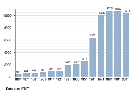
Demographic evolution
Twin towns
Pero is twinned with:

References
External links

This article is issued from
Wikipedia.
The text is licensed under Creative Commons - Attribution - Sharealike.
Additional terms may apply for the media files.