Nerviano
| Nerviano | ||
|---|---|---|
| Comune | ||
| Comune di Nerviano | ||
 | ||
| ||
 Nerviano Location of Nerviano in Italy | ||
| Coordinates: 45°33′N 8°59′E / 45.550°N 8.983°E | ||
| Country | Italy | |
| Region | Lombardy | |
| Metropolitan city | Milan (MI) | |
| Frazioni | Cantone, Costa San Lorenzo, Garbatola, Sant'Ilario, Villanova | |
| Government | ||
| • Mayor | Massimo Cozzi | |
| Area | ||
| • Total | 13.5 km2 (5.2 sq mi) | |
| Elevation | 175 m (574 ft) | |
| Population (28 February 2017)[1] | ||
| • Total | 17,267 | |
| • Density | 1,300/km2 (3,300/sq mi) | |
| Demonym(s) | Nervianesi | |
| Time zone | UTC+1 (CET) | |
| • Summer (DST) | UTC+2 (CEST) | |
| Postal code | 20014 | |
| Dialing code | 0331 | |
| Patron saint | San Fermo | |
| Website | Official website | |
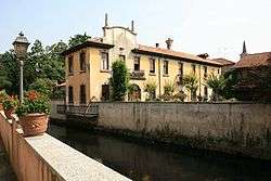
Nerviano (Lombard: Nervian [nerˈʋjãː]) is a comune (municipality) in the northwestern part of the Metropolitan City of Milan in the Italian region Lombardy, located about 15 kilometres (9 mi) northwest of downtown Milan. Its territory is crossed by the Olona river and by the Villoresi Canal.
References
External links

This article is issued from
Wikipedia.
The text is licensed under Creative Commons - Attribution - Sharealike.
Additional terms may apply for the media files.